WhiteBlaze Pages 2024
A Complete Appalachian Trail Guidebook.
AVAILABLE NOW. $4 for interactive PDF(smartphone version)
Read more here WhiteBlaze Pages Store

Page 2 of 3 FirstFirst 1 2 3 LastLast
Results 21 to 40 of 46
  1. #21

    Default

    Quote Originally Posted by JohnHuth View Post
    I could post something on the standard way of doing celestial with a sextant, sure. Do you own one? If so, what kind?
    No I sure don't, just always found it neat. I know there's stuff on the net, I guess I was asking if you had blogged about it in your own style as your compass article read very easy for me. Thanks for the consideration.

  2. #22

    Default

    Quote Originally Posted by rocketsocks View Post
    I guess I was asking if you had blogged about it
    Not yet, but I've been getting similar requests, so I think I'll start to put something together. I'll use a plastic Davis Mk3 sextant as the teaching instrument, as they're affordable, available, and a good beginner's sextant (easy to use and surprisingly accurate).

  3. #23

    Default

    I am a regular on ESEE knife forum. You can go to their site jungletraining.com, go to links and pull up the navigation course. It's a complete PowerPoint on how you navigate with a compass. Extremely good information and it's free.

  4. #24

  5. #25
    In the shadows AfterParty's Avatar
    Join Date
    05-11-2016
    Location
    Norton, Kansas
    Age
    43
    Posts
    490
    Journal Entries
    1
    Images
    12

    Default

    Quote Originally Posted by cmoulder View Post
    LOL, I have no idea what the hell this means. Can anyone translate?
    Finding 2 known points and figuring out where you are, or someplace is.

  6. #26

    Default

    Quote Originally Posted by JohnHuth View Post
    Not yet, but I've been getting similar requests, so I think I'll start to put something together. I'll use a plastic Davis Mk3 sextant as the teaching instrument, as they're affordable, available, and a good beginner's sextant (easy to use and surprisingly accurate).
    fantastic, thanks look forward to checking it out sometime.

  7. #27
    Registered User DrRichardCranium's Avatar
    Join Date
    07-20-2009
    Location
    Frederick, MD
    Age
    59
    Posts
    442
    Journal Entries
    1

    Default

    That's some really great stuff right there.
    "Katahdin barada nikto."

  8. #28
    Registered User John B's Avatar
    Join Date
    10-04-2005
    Location
    .......................
    Age
    63
    Posts
    1,335

    Default

    It seems that almost every month, each REI store offers a compass/map reading course. It's a 2-hour course, $50 for non-members, $35 for members. I'll be taking the June 13 course at the Cincinnati REI.

  9. #29
    Clueless Weekender
    Join Date
    04-10-2011
    Location
    Niskayuna, New York
    Age
    68
    Posts
    3,879
    Journal Entries
    10

    Default

    Maps virtually always have true gridlines ruled on them.

    I could scribe my maps with magnetic gridlines, and sometimes do...
    ... but it's less work to simply set the declination of my compass and then not worry about it.

    (I also know how to do Timid Virgins Make Dull Company At Weddings - which you need to do in a vehicle, but deviation is negligible with a handheld compass away from vehicles, buildings, railroads and power lines.)
    I always know where I am. I'm right here.

  10. #30
    Registered User
    Join Date
    03-25-2014
    Location
    Westchester County, NY
    Posts
    2,305

    Default

    less work to simply set the declination of my compass and then not worry about it.


    +1

    KISS in action.

  11. #31

    Default

    Quote Originally Posted by Another Kevin View Post
    Maps virtually always have true gridlines ruled on them.

    I could scribe my maps with magnetic gridlines, and sometimes do...
    ... but it's less work to simply set the declination of my compass and then not worry about it.

    (I also know how to do Timid Virgins Make Dull Company At Weddings - which you need to do in a vehicle, but deviation is negligible with a handheld compass away from vehicles, buildings, railroads and power lines.)
    well I never heard that acronym, what it's all about?

  12. #32
    Registered User
    Join Date
    03-25-2014
    Location
    Westchester County, NY
    Posts
    2,305

    Default

    http://wawewi.com/mnemonics/index.php?p=83

    true+variation=magnetic+deviation=compass+add west (if east of the magnetic declination "zero line"


  13. #33
    Wanna-be hiker trash
    Join Date
    03-05-2010
    Location
    Connecticut
    Age
    42
    Posts
    6,922
    Images
    78

    Default

    Quote Originally Posted by Another Kevin View Post
    Maps virtually always have true gridlines ruled on them.

    I could scribe my maps with magnetic gridlines, and sometimes do...
    ... but it's less work to simply set the declination of my compass and then not worry about it.

    (I also know how to do Timid Virgins Make Dull Company Add Whiskey - which you need to do in a vehicle, but deviation is negligible with a handheld compass away from vehicles, buildings, railroads and power lines.)
    Kev: That nemonic was updated ages ago...
    Colorless green ideas sleep furiously.

  14. #34

    Default

    Quote Originally Posted by cmoulder View Post
    http://wawewi.com/mnemonics/index.php?p=83

    true+variation=magnetic+deviation=compass+add west (if east of the magnetic declination "zero line"

    thankee

  15. #35
    Registered User
    Join Date
    03-25-2014
    Location
    Westchester County, NY
    Posts
    2,305

    Default

    Quote Originally Posted by Sarcasm the elf View Post
    Kev: That nemonic was updated ages ago...
    LOL, I like "Add Whiskey"

    Reminds one of the Ogden Nash ditty: Candy is Dandy but Liquor is Quicker

  16. #36
    ME => GA 19AT3 rickb's Avatar
    Join Date
    12-12-2002
    Location
    Marlboro, MA
    Posts
    7,145
    Journal Entries
    1
    Images
    1

    Default

    Its interesting to ponder why orienteering compasses (meaning those used designed for the sport of orienteering) like thumb compasses don't adjust for declination.

    I think they see benefit in using Magnetic North marked on their maps and lining up with that and keeping things simple.

    I think it is good to know that on the east coast the compass needle points a bit left of true north, and on the west coast it points a bit right of true north and such, but for most practical purposes one can be very well served alomg the AT with a compass-- even if you ignore declination all together.

  17. #37

    Default

    Quote Originally Posted by rickb View Post
    Its interesting to ponder why orienteering compasses (meaning those used designed for the sport of orienteering) like thumb compasses don't adjust for declination.

    I think they see benefit in using Magnetic North marked on their maps and lining up with that and keeping things simple.

    I think it is good to know that on the east coast the compass needle points a bit left of true north, and on the west coast it points a bit right of true north and such, but for most practical purposes one can be very well served alomg the AT with a compass-- even if you ignore declination all together.
    Yup you're right, it'll work, but could start a domino effect of the already epidemic dumbing down of our yute.

  18. #38
    Clueless Weekender
    Join Date
    04-10-2011
    Location
    Niskayuna, New York
    Age
    68
    Posts
    3,879
    Journal Entries
    10

    Default

    Quote Originally Posted by Sarcasm the elf View Post
    Kev: That nemonic was updated ages ago...
    There's also the one that runs the other way: Chicago Dead Men Vote Twice At Elections

    Compass + Deviation = Magnetic + Variation = True (Add East)
    I always know where I am. I'm right here.

  19. #39

    Default

    Quote Originally Posted by cmoulder View Post
    http://wawewi.com/mnemonics/index.php?p=83

    true+variation=magnetic+deviation=compass+add west (if east of the magnetic declination "zero line"


    I stick to hiking straight up that red line so that I don't even have to worry about it!

  20. #40
    Clueless Weekender
    Join Date
    04-10-2011
    Location
    Niskayuna, New York
    Age
    68
    Posts
    3,879
    Journal Entries
    10

    Default

    Quote Originally Posted by rickb View Post
    I think it is good to know that on the east coast the compass needle points a bit left of true north, and on the west coast it points a bit right of true north and such, but for most practical purposes one can be very well served alomg the AT with a compass-- even if you ignore declination all together.
    True enough. But I own a mirror-sight baseplate compass, so that's what I bring. (Having a small mirror comes in handy for other purposes, anyway.)

    Orienteering is much less about compass navigation as it is about terrain reading. A thumb compass gives you enough information to orient the map roughly, and then you're typically running a handrail or running for a capture feature. You're very rarely dealing with having to take an accurate sight.

    I do a fair amount of off-trail travel, where an accurate sight, accounting for compass variation does matter, at least sometimes. It certainly matters if you're determining position with resection or estimating a distance with intersection, or you want to minimize the amount you need to "aim off" from an approach point on a distant handrail.

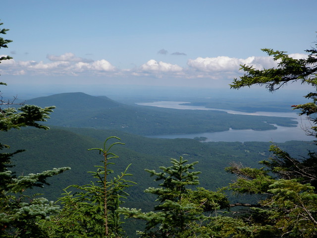
    Elf took this picture at one point when I was showing him some of the techniques.


    We recovered position - together with an error estimate, by sighting on the abutment of the bridge at far right, the barn near the highway at left center (the pattern of the buildings was visible on a topo), and the peak at left, resecting all those lines back to the ridge we were standing on. We were as near the ridge top as made no difference, so could use the ridge itself as a fourth line of position.

    The resections clustered pretty closely. When I had him cross-check with GPS, it was pretty much spot on.

    Of course, I knew where the nice overlook was, but it's good to run through the exercise.

    By the way, since Nature has no scale, I'll mention that the near shore of the lake there is about five miles off, the peak beyond is 7.4 miles from where we're standing, and the bridge is 8.1 miles. There's about three thousand feet of elevation difference between us and the valley floor, with over half of it in the first half mile. In other words, that cliff is a technical climb. We hadn't climbed it. We'd bushwhacked up the ridge from the other side and had been about a day and a half playing around in a huge trail-less space back there by the time we reached this spot.
    I always know where I am. I'm right here.

Page 2 of 3 FirstFirst 1 2 3 LastLast
++ New Posts ++

Posting Permissions

  • You may not post new threads
  • You may not post replies
  • You may not post attachments
  • You may not edit your posts
  •