WhiteBlaze Pages 2024
A Complete Appalachian Trail Guidebook.
AVAILABLE NOW. $4 for interactive PDF(smartphone version)
Read more here WhiteBlaze Pages Store

Page 4 of 4 FirstFirst 1 2 3 4
Results 61 to 76 of 76
  1. #61
    Registered User T.Bates's Avatar
    Join Date
    04-22-2016
    Location
    Culpeper, Virginia
    Age
    31
    Posts
    19

    Default

    Quote Originally Posted by Venchka View Post
    Yes. And I'm old enough to hopefully check out before they wreck it completely.


    Old. Slow. "Smarter than the average bear."
    So much hostility towards the younger generation coming from the generation that will completely wipe out social security... and we're the ones wrecking it.... I completely agree and usually try to carry two forms of navigation. I know how to navigate by compass as I was in a public school that actually taught us the basics on how to navigate but have only ever used my phone. Using a phone allows you to use the GPS, MPH, terrain, and much more. It makes much more sense to use something that is so multi-function and can do much more then a paper map. Again I do try to carry more than one form of navigation but hey, HYOH.
    If you dont know where you're going, any trail will take you there...

  2. #62
    Registered User
    Join Date
    07-21-2005
    Location
    Garner, NC
    Age
    58
    Posts
    649
    Images
    279

    Default

    For me, plan A is to follow the white blazes. Anything beyond that (e.g. maps or phone app) are at best plan B.

    Plan B, if I find myself off the trail, is to backtrack until I'm back on the trail. Maps/Phone apps are plan C in this case.

  3. #63
    •Completed A.T. Section Hike GA to ME 1996 thru 2003 •Donating Member Skyline's Avatar
    Join Date
    10-08-2003
    Location
    Luray, Virginia
    Posts
    4,844
    Images
    3

    Default

    T.Bates if you've never had technology fail on you, you are indeed a lucky millennial.

    I can't speak to the ultimate future of SS, but my thought is that your parent's generation and maybe the one preceding it, by choosing to have fewer children, are making it difficult for those currently in the (smaller) workforce to support the needs of (larger number of) older generations currently receiving SS. But I do believe it will be tweaked in important and necessary ways, and if current birth rates don't increase, SS will be OK into the future until you need it.

    Good to have more than one type of navigation, if you must. The most reliable is the analog simplest, especially on the well-blazed AT. HYOH

  4. #64
    Registered User
    Join Date
    03-23-2014
    Location
    Fayetteville, NC
    Posts
    599
    Journal Entries
    4
    Images
    7

    Default

    I carry both. GPS for on-the fly positioning and amp/compass as a backup.

    Backstory_ in the military map reading and land nav started taking a backseat to GPS. I always stressed the importance of being able to read a map to my troops. One time we were doing dismounted land nav after about three hours of doing map reading, resection, intersection, pace counts, etc. I dropped the guys off at the start point, and right before I left, I collected all their cell phones (should have seen the looks on their faces) and said "I'll see you at the finish". They had handheld radios to contact me just in case. Sure enough, about 90 minutes later they started coming in, a lot more confident in their skills.

    Bringing a map & compass & protractor is fine if you know how to use them properly. If not, stick to the GPS. There's no right or wrong answer. There are a lot of places on the AT where you can have a map all day long but all you see is rhodo tunnels or some random ridgeline. For intersection & resection to work you have to have some idea of where you are, your last point of reference or grid location or what the other features are.

    Like another poster said, a map is nice to pore over in the tent and plot out the terrain you'll be tackling the next day.
    "The woods are lovely, dark and deep,
    But I have promises to keep,
    And miles to go before I sleep,
    And miles to go before I sleep."

  5. #65
    Registered User
    Join Date
    08-05-2013
    Location
    Sacramento, CA
    Age
    77
    Posts
    1,182

    Default

    Quote Originally Posted by Gambit McCrae View Post
    Quote Originally Posted by Venchka View Post
    Or....
    Take map & compass.
    Phone with app as backup.
    Wayne
    Old. Slow. "Smarter than the average bear."
    Wayne I don't mean to be rude, but Guthooks is for AT/ PCT hikes. I have not hiked any of the PCT and only half of the AT but I can not remember a time on the AT in the southern half where a compass would have been useful, or when I could have gotten lost for the need of a compass. Northern half of the AT/ the PCT more viable for a compass?
    We know, tragically, that even an experienced hiker on the AT can get lost going off trail to the bathroom. If that happens and you have guthook, you can easily get back to the trail.

  6. #66

    Default

    Quote Originally Posted by T.Bates View Post
    So much hostility towards the younger generation coming from the generation that will completely wipe out social security... and we're the ones wrecking it.... I completely agree and usually try to carry two forms of navigation. I know how to navigate by compass as I was in a public school that actually taught us the basics on how to navigate but have only ever used my phone. Using a phone allows you to use the GPS, MPH, terrain, and much more. It makes much more sense to use something that is so multi-function and can do much more then a paper map. Again I do try to carry more than one form of navigation but hey, HYOH.
    Quote Originally Posted by Skyline View Post
    T.Bates if you've never had technology fail on you, you are indeed a lucky millennial.

    I can't speak to the ultimate future of SS, but my thought is that your parent's generation and maybe the one preceding it, by choosing to have fewer children, are making it difficult for those currently in the (smaller) workforce to support the needs of (larger number of) older generations currently receiving SS. But I do believe it will be tweaked in important and necessary ways, and if current birth rates don't increase, SS will be OK into the future until you need it.

    Good to have more than one type of navigation, if you must. The most reliable is the analog simplest, especially on the well-blazed AT. HYOH
    pretty sure we're talkin' about compasses with the little needle, not moral compasses, fur if that were the case we'd all be lost.

  7. #67
    Clueless Weekender
    Join Date
    04-10-2011
    Location
    Niskayuna, New York
    Age
    68
    Posts
    3,879
    Journal Entries
    10

    Default

    Let me speak to the "zero visibility" problem.

    I hike in the East. About a third of my hikes involve at least some off-trail travel. There's frequently very little visible in the dense vegetation. Some of my trips have been more swimming in spruce than walking.

    I carry an altimeter as well as map and compass. If I haven't forgotten which mountain I'm on, I can get a very rough fix - but good enough to guide me out of trouble - from altitude and aspect of slope: "I'm at 3250 feet and the ground is dropping off to the ESE." (follow the 3250 foot contour around the hill and find somewhere that it's running in the right direction) "OK, I must be about here."

    The altimeter is on my watch and so it could have a dead battery, and so, of course, could the GPS on my smartphone. They're all tools, and I'll happily use all of them, while saying that the map and compass are primary.

    Learn about handrails, backstops, collecting features. I use ridges and cliffs and streams and fences to locate myself all the time. I can't think of when I last did a sight resection for real (as opposed to teaching it).
    I always know where I am. I'm right here.

  8. #68

    Default

    Quote Originally Posted by Traveler View Post
    Actually the world isn't changing that much, the FAA and Nautical regulations still have language that require charts to be used (multi engine and commercial use aircraft and professionally operated vessels over 39.4 feet or over 1600 tonnes). As a pilot, I like the convenience of the GPS, but having experienced electrical problems in flight, GPS outages that can occur, and device failures, I always have a chart in my lap and routinely check my position on the chart during flight. Most all the pilots I know who fly their own aircraft have similar discipline. If the yacht captain is a professional with various ratings, he was probably right in saying he used his GPS phone gizmo most of the time to check on course, etc. But you can be sure the bridge watch had charts out not just for display of impressionable passengers, but as a navigational tool coupled with the electronics. As with aviation, most long distance travel requires the use of larger charts for a reasonably accurate view of the course and any changes that have been made. Anything not necessary for the safe conduct of the voyage/flight is usually not just laying around given cockpit and bridge resource/space management needs. If they are laying about and not being used for reference its not a very professional demonstration of good seamanship.

    As pointed out, GPS is a tool that really depends on where you are and what you are doing that dictates if having either a map, a GPS, or both is a good idea. FWIW, I tend to carry maps all the time, with GPS as a back up tool on unfamiliar terrain. As Elf points out, the AT is a unique, well marked and worn trail that GPS is fairly well suited for and is often said to be all one needs. However, that advice may not serve well on other trails that are less worn, marked, and maintained. An electronic failure of any cause could prove to be a real problem.
    Good info.

    BTW, redundancy despite the UL advice to avoid it sometimes is prudent IMO. i.e; two ways to start fire one beyond depending on a lighter, especially during winter, possibly two pr socks of varying characteristics, two light sources, etc. It depends.

  9. #69

    Default

    Quote Originally Posted by Another Kevin View Post
    Let me speak to the "zero visibility" problem.

    I hike in the East. About a third of my hikes involve at least some off-trail travel. There's frequently very little visible in the dense vegetation. Some of my trips have been more swimming in spruce than walking.

    I carry an altimeter as well as map and compass. If I haven't forgotten which mountain I'm on, I can get a very rough fix - but good enough to guide me out of trouble - from altitude and aspect of slope: "I'm at 3250 feet and the ground is dropping off to the ESE." (follow the 3250 foot contour around the hill and find somewhere that it's running in the right direction) "OK, I must be about here."

    The altimeter is on my watch and so it could have a dead battery, and so, of course, could the GPS on my smartphone. They're all tools, and I'll happily use all of them, while saying that the map and compass are primary.

    Learn about handrails, backstops, collecting features. I use ridges and cliffs and streams and fences to locate myself all the time. I can't think of when I last did a sight resection for real (as opposed to teaching it).
    What are all those things? No one EVER EVER needs to learn about such mumbo jumbo. Redundant.

  10. #70
    Registered User Venchka's Avatar
    Join Date
    02-20-2013
    Location
    Roaring Gap, NC
    Age
    78
    Posts
    8,529

    Default

    Quote Originally Posted by FlyPaper View Post
    For me, plan A is to follow the white blazes. Anything beyond that (e.g. maps or phone app) are at best plan B.

    Plan B, if I find myself off the trail, is to backtrack until I'm back on the trail. Maps/Phone apps are plan C in this case.
    For those of us who hike where white blazes are nonexistent, we need to pay attention to our navigation methods.
    Leaving tomorrow for a decades overdue backpacking trip in 2 wilderness areas in southern Colorado including sections of the CDT. Maps by CalTopo. Compass by Silva. App by Guthook.
    Wayne


    Old. Slow. "Smarter than the average bear."
    Eddie Valiant: "That lame-brain freeway idea could only be cooked up by a toon."
    https://wayne-ayearwithbigfootandbubba.blogspot.com
    FlickrMyBookTwitSpaceFace


  11. #71

    Default

    Downloaded Guthook yesterday as that is the only app I have seen mentioned lately.Nice!

    First thing it tells you is "electronic devices can and do fail".Whoda thunkit?

    The battery on my map has never failed me and it works when damp.AGG bandana with Trail Guide Info on it
    likely the best invention for a good general approach.

  12. #72

    Default

    Add Content

  13. #73
    Clueless Weekender
    Join Date
    04-10-2011
    Location
    Niskayuna, New York
    Age
    68
    Posts
    3,879
    Journal Entries
    10

    Default

    Quote Originally Posted by Dogwood View Post
    What are all those things? No one EVER EVER needs to learn about such mumbo jumbo. Redundant.
    I laughed out loud when I read that, thanks!

    But given the ways of the Internet, I feel compelled to point out: HE'S JOKING!
    I always know where I am. I'm right here.

  14. #74
    Registered User
    Join Date
    08-05-2013
    Location
    Sacramento, CA
    Age
    77
    Posts
    1,182

    Default

    Quote Originally Posted by Five Tango View Post
    Downloaded Guthook yesterday as that is the only app I have seen mentioned lately.Nice!
    Halfmile is another good one. At least for the PCT. One thing it has is a little arrow that will point you back to the trail - you can't get much easier than that!

  15. #75
    Wanna-be hiker trash
    Join Date
    03-05-2010
    Location
    Connecticut
    Age
    42
    Posts
    6,922
    Images
    78

    Default

    Quote Originally Posted by Another Kevin View Post
    Let me speak to the "zero visibility" problem.

    I hike in the East. About a third of my hikes involve at least some off-trail travel. There's frequently very little visible in the dense vegetation. Some of my trips have been more swimming in spruce than walking.

    I carry an altimeter as well as map and compass. If I haven't forgotten which mountain I'm on, I can get a very rough fix - but good enough to guide me out of trouble - from altitude and aspect of slope: "I'm at 3250 feet and the ground is dropping off to the ESE." (follow the 3250 foot contour around the hill and find somewhere that it's running in the right direction) "OK, I must be about here."

    The altimeter is on my watch and so it could have a dead battery, and so, of course, could the GPS on my smartphone. They're all tools, and I'll happily use all of them, while saying that the map and compass are primary.

    Learn about handrails, backstops, collecting features. I use ridges and cliffs and streams and fences to locate myself all the time. I can't think of when I last did a sight resection for real (as opposed to teaching it).
    What kind of nut would want to hike like that?
    image.jpg
    Colorless green ideas sleep furiously.

  16. #76
    Clueless Weekender
    Join Date
    04-10-2011
    Location
    Niskayuna, New York
    Age
    68
    Posts
    3,879
    Journal Entries
    10

    Default

    Quote Originally Posted by Sarcasm the elf View Post
    What kind of nut would want to hike like that?
    image.jpg
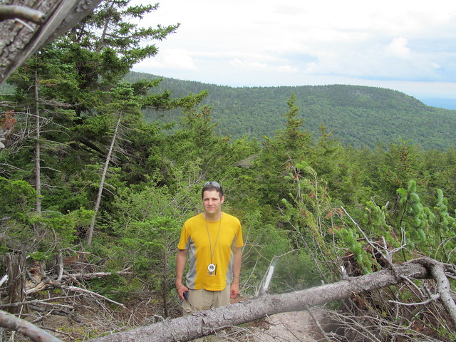
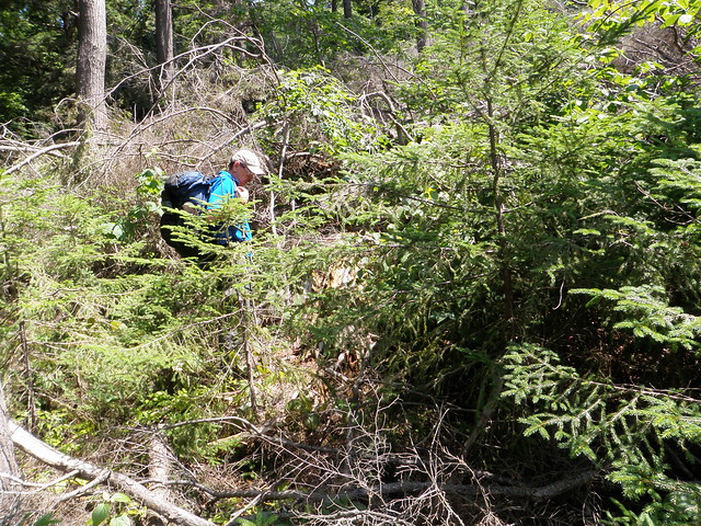
    This kind?


    Or this kind?


    The technical term for that particular sort of nut is 'bush-whacko.'

    The pictures are also illustrating some more equipment that's nice to have. (Click through twice to see in more detail.) Note that the hikers in both pictures are wearing safety glasses. They're an absolute must for hiking in that sort of terrain. (In winter, I replace the safety glasses with USMC surplus flight-deck goggles.) And in the second picture, the hiker in the blue shirt is pulling a bead on a pace counter. Paces can be estimated only very roughly in bad terrain, of course, but even a rough estimate is better than nothing. The ranger beads are an important navigational instrument that I neglected to mention in my last post!

    Aside to Elf: I still haven't managed to do Friday Mountain. My foot finally seems to be healing... I'm at least managing a few miles on relatively easy trail. Maybe I'll be up to finishing in 2017. It's frustrating - just six climbs to go! All of them in similar terrain, of course.
    I always know where I am. I'm right here.

Page 4 of 4 FirstFirst 1 2 3 4
++ New Posts ++

Posting Permissions

  • You may not post new threads
  • You may not post replies
  • You may not post attachments
  • You may not edit your posts
  •