WhiteBlaze Pages 2024
A Complete Appalachian Trail Guidebook.
AVAILABLE NOW. $4 for interactive PDF(smartphone version)
Read more here WhiteBlaze Pages Store

Results 1 to 16 of 16
  1. #1
    Clueless Weekender
    Join Date
    04-10-2011
    Location
    Niskayuna, New York
    Age
    68
    Posts
    3,879
    Journal Entries
    10

    Default A bit of no-blazing in the Catskills, with Another Kevin and Sarcasm the elf

    Last weekend, Sarcasm the elf and I went out for a tour of the Bushwhack Range. Between oversleeping on Sunday because of a storm Saturday night, and getting delayed by a big field of blowdown coming up to Balsam Cap from the west, we had to decide that Friday would be there another day, but we made the other three.

    I suppose that 'Other Trails' is the best spot to put this, since we used about a mile of the Finger Lakes Trail and maybe 300 yards of the New York Long Path as access trails, but most of the weekend was off trail entirely.

    Trip report over at my blog.
    If you're curious what a Catskill bushwhack is like, this report should give some of the flavor of it.


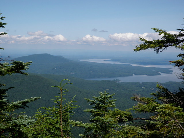
    View from Balsam Cap by ke9tv, on Flickr


    View from Rocky by ke9tv, on Flickr


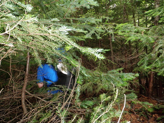
    In the balsam spruce by ke9tv, on Flickr
    I always know where I am. I'm right here.

  2. #2
    Registered User Teacher & Snacktime's Avatar
    Join Date
    02-14-2013
    Location
    Warren, RI
    Posts
    2,602
    Journal Entries
    32
    Images
    827

    Default

    Incredible pics, AK....nice report!
    "Maybe life isn't about avoiding the bruises. Maybe it's about collecting the scars to prove we showed up for it."

  3. #3

    Default

    Very nice, really enjoyed that, thanks for postin' AK. Sounds and looks like you boys really earned those summits, nice job to you both! and a beautiful shot of the Ashokan valley.

  4. #4
    Registered User Driver8's Avatar
    Join Date
    08-24-2010
    Location
    West Hartford, Connecticut
    Posts
    2,672
    Images
    234

    Default

    What a great outing, KK. Glad y'all soldiered through and had a good time. I am keen to extend my nav skills, would enjoy hiking with you before long, and also want to get to the 'skills, where I've yet to hike. Let's talk!
    The more miles, the merrier!

    NH4K: 21/48; N.E.4K: 25/67; NEHH: 28/100; Northeast 4K: 27/115; AT: 124/2191

  5. #5
    Registered User
    Join Date
    03-22-2009
    Location
    Ashburnham, MA
    Age
    80
    Posts
    1,951
    Images
    2

    Default

    Very nice trip, great report and pics! Looking at your map, there are some interesting hikes that could be done (say linking Lone, Rocky, Balsam Cap, Friday, Cornell, Wittenberg). Looking at your pictures I should have tried that 40 or 50 years ago. Perhaps a more reasonable trip might be Friday-Cornell-Wittenberg then out to Woodland Valley camp ground. What do you think of the possibility of making it from Friday to Cornell? The Wittenberg-Cornell-Slide mountain hike was one of the nicest I ever took. I've really got to get back to the Catskills!

    Of course when I saw the picture of the Ashokan I had to listen to Jay Unger's "Ashokan Farewell". https://www.youtube.com/watch?v=2kZASM8OX7s

  6. #6

    Default

    Quote Originally Posted by Snowleopard View Post
    Very nice trip, great report and pics! Looking at your map, there are some interesting hikes that could be done (say linking Lone, Rocky, Balsam Cap, Friday, Cornell, Wittenberg). Looking at your pictures I should have tried that 40 or 50 years ago. Perhaps a more reasonable trip might be Friday-Cornell-Wittenberg then out to Woodland Valley camp ground. What do you think of the possibility of making it from Friday to Cornell? The Wittenberg-Cornell-Slide mountain hike was one of the nicest I ever took. I've really got to get back to the Catskills!

    Of course when I saw the picture of the Ashokan I had to listen to Jay Unger's "Ashokan Farewell". https://www.youtube.com/watch?v=2kZASM8OX7s
    love that tune...thanks for postin'

  7. #7
    Clueless Weekender
    Join Date
    04-10-2011
    Location
    Niskayuna, New York
    Age
    68
    Posts
    3,879
    Journal Entries
    10

    Default

    Friday to Cornell is a very difficult hike, even by the standards of Catskill bushwhacks. I know several people who've done it, and they all say that they'd never do it again. The spruce-balsam forest is nearly impenetrable. Everyone reports patches where they were going through on hands and knees because they couldn't push through standing. There are also a couple of unstable recent rock slides on the stretch between Friday and Dink (the local name for the officially unnamed height of land south of Cornell). Then you still have to get up the ledges on Cornell. The easiest way is to angle west and intercept the Garden Path well below the summit. Otherwise, there's supposedly an abandoned trail that leads up to the summit clearing through a rock chute, but I don't know anyone who's actually found it. (There's another - equally hard to find - from Maltby Hollow to Bruin's Causeway between Wittenberg and Cornell. Supposedly it gets through the ledges somehow.)

    I hear that the direct route through the col from Rocky to Balsam Cap isn't absolutely horrible, but on the trip last weekend, I wanted to get back to the Neversink to camp. This is one trip where a hammock would really have been a good idea. The col between Table and Lone is another spot that's harder than it looks. It's a 'knife edge' trail with steep dropoffs (as in, I'd want a belay and helmet) on both sides, and thick evergreens on top.

    Some of my hiking partners say that the whole area is easier on snowshoes. The idea that anywhere is actually easier on snowshoes boggles the mind, but I can see where they're coming from!

    The other whack that's supposed to be rewarding is Samuels Point, the high point a couple of miles east of Cornell. It's accessed by bailing off the Burroughs Range trail from Woodland Valley before it starts climbing Wittenberg in earnest, walking around to the ridge on the clifftop, and then taking the ridge out. It's supposed to have the best views of the Ashokan, better even than Wittenberg.

    To the north, there's now an off-road connection open across Romer Mountain between Wittenberg and Phoenicia. So it's actually possible to hike thru on the NY Long Path from Huntersfield Mountain in the north to Peekamoose in the south, over Blackhead, through Dutcher Notch, around North-South Lake, across Kaaterskill High Peak, over the eastern half of the Devil's Path, and across the Burroughs Range, Table and Peekamoose, with the only road crossings being 23 in Windham, 23A in Kaaterskill Clove, Platte Clove Road, and 28 in Phoenicia, and with Phoenicia village and the bridge over the Esopus being the only significant roadwalk. That really makes the Catskill section of the Long Path complete, and it's a heck of a trip! (One of these times, I have to do the new Romer Mountain and Warner Creek sections, I haven't hiked them yet.)

    You're right that the Burroughs Range trail is great. I did that one back in October, and it's fine hiking. The Catskills are underrated in general. This is stuff that rivals northern New England - a park you can get lost in - that's two hours from New York City! Tough hiking, great fishing, world-class climbing, and everywhere you point a camera looks like a Hudson River School painting.

    Jay and Molly are also great. Heard them most recently at a charity performance this spring at Schenectady First Unitarian, which is a really nice, intimate performance space. Of course they finished with Ashokan Farewell. Now Jay's fiddle will be running through my head all evening. Oh well, there are worse tunes to have there.
    I always know where I am. I'm right here.

  8. #8
    Registered User
    Join Date
    03-22-2009
    Location
    Ashburnham, MA
    Age
    80
    Posts
    1,951
    Images
    2

    Default

    Back in the late 1960s and 1970s, I did a lot of day hikes and bushwhacking in the northern catskills, around Ashland in Greene County. My parents were living there then. Nothing I did then was as nasty as your whack. Mostly it was fairly easy hiking but sometimes steep. I also did quite a bit of bushwhacking there and around Oneonta on xc skis, but I had no one to ski with so I was fairly cautious about how far out I went.

    I'm afraid I'm getting too old (70yo) for crawling any great distance. I did that once in winter trying to xc ski from a friend's house up the backside of Okemo Mt. in VT (4'+ of snow too crusty to ski, not crusty enough to walk, so crawled 1/2 the last few miles. I think it would have been even harder in summer because the snow got you above the brush. Still, you get to see some amazing things in unvisited woods.

    Kevin, do you have a favorite hike in the Catskills?

  9. #9

    Default

    Nice to see you guys did it in one of my favorite day-hike places. It brings me back so much memories!
    This is probably the best bushwhacking route (unmaintained trail? herd path?) in Catskills. I knew it there quite a while back and even wanted to try it myself someday. Been up Burroughs Range (or half way) at least five times, Ashokan Reservoir looks distinctively familiar to me. I usually took a closed route for my three day backpacking trip, Woodland Valley parking lot>Wittenberg>Cornell>Slide>Giant Ledge>Woodland Valley parking lot.
    The col between Cornell and Slide seems to have water shortage most time in a year. There could be a small stream less than half way up from the col to Slide. I clearly remember there's a very nice trickling on a short spur trail about 10 minutes to Slide, where I filled up my water bottles in my last trip two years ago.

  10. #10
    Clueless Weekender
    Join Date
    04-10-2011
    Location
    Niskayuna, New York
    Age
    68
    Posts
    3,879
    Journal Entries
    10

    Default

    Quote Originally Posted by Snowleopard View Post
    Kevin, do you have a favorite hike in the Catskills?
    Oh, so many to choose from! The Hunter Mountain loop from Spruceton. The Burroughs Range. The eastern Devil's Path. The dozens of views you can get from the North-South Lake area for very little effort. Overlook, Echo Lake, Codfish Point and Plattekill Falls. Really hard to choose!

    If I had to pick just one, I think it would have to be the northern Escarpment. Start from Barnum Road and hike Caudal, Camel's Hump, Thomas Cole, Black Dome, Blackhead. Turn left and come down the north side of Blackhead. Camp at Batavia Kill - lots of tent sites near the lean-to. Next day, walk over Acra Point, Burnt Knob, Windham High Peak, and come out on Elm Ridge with a 2-3 mile roadwalk back to Barnum Road. Stunning views from lots of places, and you get all the hard scrambles out of the way on the first day.

    I'm realizing, too, that with all of the trail work they've done in the last few years, that the NY Long Path through the Catskills, say, sections 16-27, is now a real trail, not a disjointed series of pieces of other trails connected by long roadwalks. The new sections would now make for an awesome 110-mile section hike, from Riggsville to Conesville, with next to no roadwalk (mostly to get across the Rondout, the Esopus, the Kaaterskill and the Catskill), and decent resupply possibilities in Phoenicia and Palenville. (Most of the rest of the Long Path still leaves a lot to be desired.) This would be one to plan for 8-10 mile days, at least unless you know you can do more on fall-line trails in actual mountains. I'm going to have to try this hike one of these years. I've done a lot of the pieces, and the ones I've done are all fantastic hiking.
    I always know where I am. I'm right here.

  11. #11
    Clueless Weekender
    Join Date
    04-10-2011
    Location
    Niskayuna, New York
    Age
    68
    Posts
    3,879
    Journal Entries
    10

    Default

    Quote Originally Posted by Highway Man View Post
    The col between Cornell and Slide seems to have water shortage most time in a year. There could be a small stream less than half way up from the col to Slide. I clearly remember there's a very nice trickling on a short spur trail about 10 minutes to Slide, where I filled up my water bottles in my last trip two years ago.
    Yeah, the Slide Mountain spring has sweet water, and it never fails. Best tasting spring in the Catskills. But there's hard scrambling to get up to it from the Garden Path. There's also a spring about midway between Cornell and Slide. You'll notice as you pass that there's a muddy spot on the trail. If you hunt around there, you'll find the seep it's coming out of. It's yellowish in colour in the summer, because it's filtering through a lot of duff, but it tastes ok, not horribly tannic. That's what I'd wind up drinking if I camped up there after coming over Cornell.

    The Burroughs Range loop is a great trip, with or without the side trip to Giant Ledge (and at least once, I threw in Panther as well). I like doing it in two days from the Giant Ledge parking lot, stopping somewhere near the Terrace Mountain trail junction, low enough to tank up from one of the springs. That breaks up the long slog up Wittenberg.
    I always know where I am. I'm right here.

  12. #12
    Registered User
    Join Date
    03-22-2009
    Location
    Ashburnham, MA
    Age
    80
    Posts
    1,951
    Images
    2

    Default

    AnotherKevin, thanks for the recommendations.

    I agree that the northern Escarpment is great, though I haven't done it in years. The Blackhead range is a favorite of mine. The long trail and Devil's path I've never done. Well I've bushwhacked some northern parts of the long trail before there was a trail there (Huntersfield Mountain, Ashland Pinnacle, and parts of that ridge). The names change. We used to have a really old map of Ashland and what's now called Huntersfield it called Ashland Pinnacle (makes sense because Huntersfield is the high point in town not what the modern maps call Ashland Pinnacle).

    This fall I'll try to get back there.

  13. #13
    Wanna-be hiker trash
    Join Date
    03-05-2010
    Location
    Connecticut
    Age
    42
    Posts
    6,922
    Images
    78

    Default

    It's been a very busy weekend so I haven't had a chance to really read over the trip report until now. I don't have much to add except a hearty thank you to Kevin for taking me along on the off trail trip. It had been almost half a lifetime (for me) since my childhood trail blazing and I had forgotten how much fun it is to ditch the blazes and head off onto a route.

    We were scratched, we were battered, we wore safety glasses and we hand a blast! From Saturday at noon until Monday when we arrived at the parking lot we didn't see another human being. I had also completely forgotten that I actually had a decent bit of skill at recognizing and following game/herd paths. Kevin is great people, he was grateful that I was okay with his speed, I was grateful that he was okay with my lacking navigation skills and it made a great combination...plus, no matter what he says, tree-hopping through the patch tornado blowdown was flat-out fun!
    Colorless green ideas sleep furiously.

  14. #14
    Registered User Driver8's Avatar
    Join Date
    08-24-2010
    Location
    West Hartford, Connecticut
    Posts
    2,672
    Images
    234

    Default

    Quote Originally Posted by Sarcasm the elf View Post
    plus, no matter what he says, tree-hopping through the patch tornado blowdown was flat-out fun!
    This sounded like one of those things that's an awesome adventure that you don't want to repeat too often but are glad you did, once it's over.
    The more miles, the merrier!

    NH4K: 21/48; N.E.4K: 25/67; NEHH: 28/100; Northeast 4K: 27/115; AT: 124/2191

  15. #15
    Wanna-be hiker trash
    Join Date
    03-05-2010
    Location
    Connecticut
    Age
    42
    Posts
    6,922
    Images
    78

    Default

    Quote Originally Posted by Driver8 View Post
    This sounded like one of those things that's an awesome adventure that you don't want to repeat too often but are glad you did, once it's over.
    Honestly I love tree hopping as long as time is not a constraint and you have the time to do it carefully a pile of blowdowns is flat out fun.

    Be like water don't be hurried don't fight the obstacle just pass it by and it will be fun.
    Last edited by Sarcasm the elf; 07-28-2014 at 01:18.
    Colorless green ideas sleep furiously.

  16. #16
    Clueless Weekender
    Join Date
    04-10-2011
    Location
    Niskayuna, New York
    Age
    68
    Posts
    3,879
    Journal Entries
    10

    Default

    Quote Originally Posted by Snowleopard View Post
    The names change. We used to have a really old map of Ashland and what's now called Huntersfield it called Ashland Pinnacle (makes sense because Huntersfield is the high point in town not what the modern maps call Ashland Pinnacle).
    The names change indeed! It's intriguing to look at one of the old guidebooks like Rusk's Illustrated Guide to the Catskill Mountains or one of the Van Loan road maps and railroad guides and see just how much things have changed (Scoharie Peaks -> Twin Mountain; Mink Mountain -> Sugarloaf; North Mountain -> Stoppel Point, and don't even get me started about how DEC signed the overlooks near North/South Lake with the names all scrambled around....) The old maps also give bushwhack ideas. The roads that aren't there any make for give some interesting hiking.

    Quote Originally Posted by Sarcasm the elf View Post
    It's been a very busy weekend so I haven't had a chance to really read over the trip report until now. I don't have much to add except a hearty thank you to Kevin for taking me along on the off trail trip. It had been almost half a lifetime (for me) since my childhood trail blazing and I had forgotten how much fun it is to ditch the blazes and head off onto a route.

    We were scratched, we were battered, we wore safety glasses and we had a blast! From Saturday at noon until Monday when we arrived at the parking lot we didn't see another human being. I had also completely forgotten that I actually had a decent bit of skill at recognizing and following game/herd paths. Kevin is great people, he was grateful that I was okay with his speed, I was grateful that he was okay with my lacking navigation skills and it made a great combination...plus, no matter what he says, tree-hopping through the patch tornado blowdown was flat-out fun!
    Yes, it was fun, wasn't it? Even if Elf's Z-rest will never be the same. I'm afraid it left a trace. Elf's great people, too. It's nice to go with someone with a compatible hiking style, or at least an adaptable one.

    If anyone's interested in more of the same kind of fun, drop me a line.! I'm always hurting for hiking partners - most of the people I'd go with say that this not their sort of trip. Solo bushwhacking is a little beyond my risk tolerance. I don't mind soloing a popular route in warm weather, but I want company for a winter trip or an extended bushwhack. I still have seven trail-less peaks on my Catskill tally sheet, and I'm getting to where I'm being a little obsessive about peak-bagging, since I'm just about 3/4 of the way through the list. The outing could be anything from a day trip to a 3-day weekend. I'd be willing to take time off midweek if that would suit someone's schedule better.
    I always know where I am. I'm right here.

++ New Posts ++

Tags for this Thread

Posting Permissions

  • You may not post new threads
  • You may not post replies
  • You may not post attachments
  • You may not edit your posts
  •