Our favorite dayhike is the Honey Creek Loop, located in the southwestern end of Big South Fork National River and Recreation Area, northwest of Knoxville.
The loop is 5 1/2 miles long, but we only do half of it. The other half just isn't that great, so we don't bother with it. There's a road through the middle of the loop, making it easy to exit after 3 miles. For those in my area who want an exciting trail, you should check this one out. It's hard to get to, but for a trail so short, this one is packed with adventure!
IMG_0972.jpg
We start at the overlook. Below us is the Big South Fork of the Cumberland River.
IMG_0977.jpg IMG_0980.jpg
The trail immediately descends three long very steep ladders to get past otherwise impassable cliffs. The descent continues for a few minutes on a switch-backed trail before turning left and following a tributary, Honey Creek, or maybe that's White Oak Creek - I haven't looked at the map in a while.
IMG_0984.jpg
Much of the trail is rocks and roots along the edge of the creek. It is the most rugged trail I've been on in our area. Though not steep (except at the ladders), there are so many obstacles to navigate that 1 mph is a pretty good pace. We hiked it yesterday in a group of twelve, including a 9-year-old boy, a 6-year-old girl, and 10-month-old boy. If you bring children on this trail, watch them closely! There are many places to get hurt, including sheer drops. (Several years ago, we were with a larger group on this trail and discovered after reaching the cars that we'd lost a 9-year-old boy. It was becoming dark. The Honey Creek loop is no place to be in the dark without a flashlight! Several people hurried back on the trail to search while someone tried to get a cell signal. After a few minutes, he was found crying and scared. He had left the last waterfall a short while after some older kids, unnoticed by the adults, and turned right instead of left at the main trail. Huge relief!)
The older children led the group much of the way (just ahead of me), and did an awesome job. I heard no complaints about the difficulties. They had loads of fun!Encompassing 125,000 acres of the Cumberland Plateau, Big South Fork National River and Recreation Area protects the free-flowing Big South Fork of the Cumberland River and its tributaries. The area boasts miles of scenic gorges and sandstone bluffs, is rich with natural and historic features and has been developed to provide visitors with a wide range of outdoor recreational activities. http://www.nps.gov/biso/planyourvisit/hiking.htm
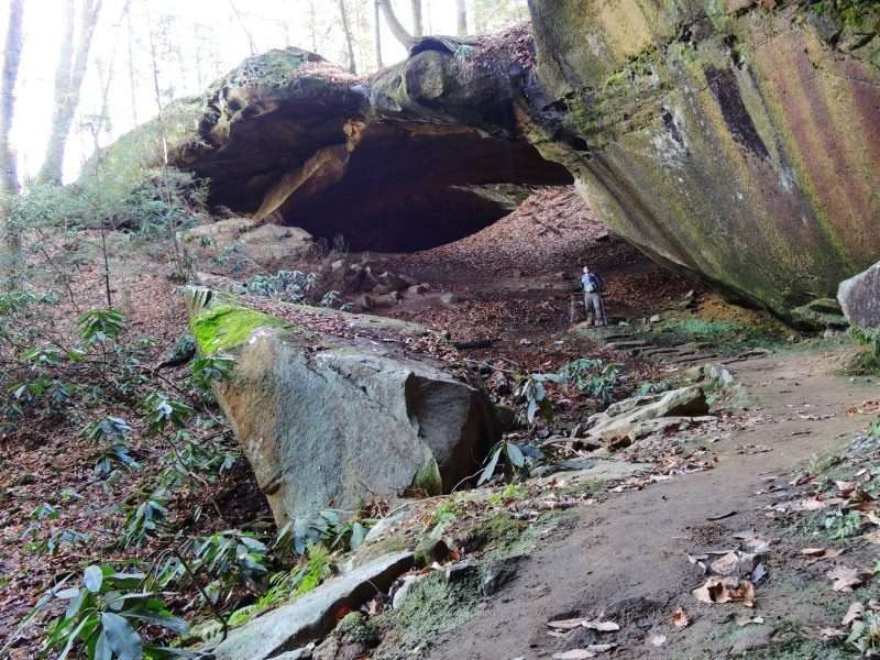
Because of the geology of the area, BSF has several "Indian Rockhouses" - shallow caves under massive sandstone overhangs.
IMG_0994.jpg
In addition, it boasts the largest stone arches east of the Mississippi (further north, close to Kentucky), and a handful of natural bridges. This creek is in a gorge cut into the rock, narrow in places with steep walls, and wider elsewhere, but still in the gorge - so don't go here if there's any chance of a flash flood; it could be dangerous.
IMG_0981.jpg
We had a good rain last Tuesday, and the creek was higher than usual. That's good. More water means more fun! Often we walk below bluffs that drip water onto the trail and our heads. We skirt the edge of the creek as we make our way upstream, climbing over large boulders, crawling on all fours across the slick bare "trail" worn on otherwise mossy boulders in the middle of the stream, stooping/leaning/crawling through small rock jumbles or "caves" - and learning how difficult this is with a baby on your back. There were some close calls with the rocks in those caves! Eventually we get to the point where the distance from one particular rock to the ledge ahead is too far for most of us. The long-legged ones stretch across, and swing the rest of us over one by one while the water spills over the ledge to our left.
Here the gorge narrows and the creek becomes the trail. All hope of staying dry is surrendered. The water depth varies from one to eight or so inches, depending on where the ledges and channels are. Everything is slick. We hold onto the rock wall, roots, trekking poles, and each other. Nobody is bored. There's no small talk to pass the time. Everyone's attention is on staying upright and as dry as possible.
IMG_0986.jpg
We cross a small channel, go around a huge boulder, navigate along the edge of a pool, turn around a bend, and the gorge opens up a bit. To the left, across the water, is a beat up ladder. Some of us climb it and explore a small cavern twenty feet above the creek. Two consecutive steps of the ladder are poorly secured and scared my 6yo granddaughter, but she was brave, and I was right with her to keep her safe.
IMG_0993.jpg
Later the trail climbs above a cave and takes us within 3 feet of the edge of an overhang. Other than vegetation (including some trees), there's nothing to stop you from falling over if you slip. Watch your step, and keep a hand on the children through here!
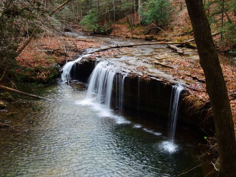
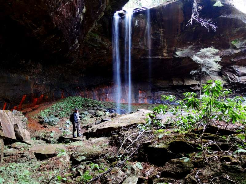
Sometime later we get to the first of three small waterfalls, Boulder House Falls. This one is at the back of a cave-like structure made from enormous boulders lying in the stream. It's loud in there.
IMG_0998.jpg
The second, Ice Castle Falls, is a thin flow from the 40- or 50-foot top of one of those overhangs. It splashes onto a small rock pile well out of the creek, so it's very accessible. In warm weather it's fun to run through it and enjoy the chill. The third is Honey Creek Falls, on a short side trail. It has a decent flow with maybe a 15-foot drop into a largish pool. The sides of the gorge are narrow here. If the water isn't too high, you can hold onto the rough rock face on the left side, and work your way back. Some sort of mustard-colored mineral oozes from the rock face. When you reach the waterfall, if you don't mind getting soaked, you can slip behind it. I saw a rattlesnake back there on a previous trip.
We returned to the main trail and turned left. About half an hour of hiking remained, with stream crossings, slick rocks, wet leaves, and finally a glimpse of cars parked where we'd left them at the halfway point of the loop.
By this time, it was 7:15, a full three hours since we'd started, and getting dim. We retrieved a car from the overlook, ate a few snacks, and made our way back to civilization feeling exhilarated and strong.


 Reply With Quote