WhiteBlaze Pages 2024
A Complete Appalachian Trail Guidebook.
AVAILABLE NOW. $4 for interactive PDF(smartphone version)
Read more here WhiteBlaze Pages Store

Page 1 of 2 1 2 LastLast
Results 1 to 20 of 30
  1. #1
    Registered User
    Join Date
    06-21-2014
    Location
    North Carolina
    Age
    35
    Posts
    19

    Default First Time AT Section Hike - Springer to NC Border

    I've been wanting to do a section hike for a while and I'm living in North Carolina now so I figure now is the time. My plan is to do Springer to the NC Border, not sure if I want to do NOBO or SOBO though. I live in Raleigh and my girlfriend is going to drop me off and pick me up (she is amazing), so I have some options. I have free time from the 2nd of August until the 11th. My original plan was to start at Springer and have her pick me up near Franklin, NC. But I've been considering going SOBO recently. My questions are these. What is the hiker traffic like at this time of the year, are the shelters going to be full? Any opinion on what direction to go? And last but most importantly, is that section doable in 8-9 days?

    Gear Breakdown
    Pack - Kelty Pawnee 50 (56z) - not crazy heavy but not an UL by any means, gets the job done
    Tent - Sierra Designs Flashlight 2 UL - (56oz) - thinking about leaving if shelters would be empty
    Bag - REI PolarPod Lite Long - (48oz) - considering leaving this as it is on the heavy side and it's August; maybe a quilt or light blanket
    Pad - Hyalite Adventurer - (30oz) - pretty good comfort, little heavy but not bad
    Stove - MSR MicroRocket or Fancy Feast Alcohol - haven't tested the fancy feast out but would save some weight
    Clothing - Mountain Hardwear Refueler 2-in-1 short, Mountain Hardwear Wicked Lite T, Smart Wool PhD Run Sock (2 pair), New Balance Minimus Shoes, hat, sunglasses - figured I don't need extra clothes for a short trip (girlfriend is gonna love me), trekking poles
    Extras/Hydration - Klean Kanteen 40oz, 2 CamelBak 100oz bladders, Sawyer Mini filter, GSI Haulite Cookset, Gerber multitool, 550 paracord (50ft), bic lighter, spork, food (still planning), GPS, paper map, phone, iPod, first aid kit, microfiber towel, trowel

    Any suggestions/tips would be greatly appreciated.

  2. #2

    Default

    I hiked that same section in late September. The majority of the hikers were going NOBO during that time. I would not worry about the shelters being full because you have a tent with you. As a matter of fact, I never stayed near the shelters. There are so many camp spots throughout that section, you can pretty much hike all day and pick a spot to set up camp during your last hour. There aren't too many spots that aren't within an hour walk of where you stand. There is a road crossing 3 miles south of the NC/GA border where you can get picked up or dropped off. It is at 34°57'31.24"N, 83°35'46.74"W. I believe it is called Charlie's Creek Rd. It should be a great time.
    Whether you think you can, or think you can't--you're right--Henry Ford; The Journey Is The Destination

  3. #3

    Default

    Would love to hear how your trip goes. I am planning the same trip starting Saturday before Labor Day.

  4. #4
    Ricky and his Husky Jack
    Join Date
    05-04-2014
    Location
    Dalton, Georgia, United States
    Age
    40
    Posts
    794
    Images
    14

    Default

    have you ever been to Amicalola? If not, I recommend even starting there (even though its not the A.T, officially) but theres a great visitor center (a few snack items, A.T. books, taxidermy animals etc) and a beautiful water fall that you would always remember.

    If you never been there, I would at least visit it.
    Me: Ricky
    Husky: Jack
    Skeeter-Beeter Pro Hammock.
    From Dalton, Georgia (65 mi above Altanta, 15mi south of Chattanooga)

  5. #5
    Registered User
    Join Date
    06-21-2014
    Location
    North Carolina
    Age
    35
    Posts
    19

    Default

    Quote Originally Posted by Ricky&Jack View Post
    have you ever been to Amicalola? If not, I recommend even starting there (even though its not the A.T, officially) but theres a great visitor center (a few snack items, A.T. books, taxidermy animals etc) and a beautiful water fall that you would always remember.

    If you never been there, I would at least visit it.
    I have not been there no. Maybe I can get my girlfriend to stay a while and check it out for the day before I set out.

    Also, anybody know the bear situation along that section?

  6. #6
    Ricky and his Husky Jack
    Join Date
    05-04-2014
    Location
    Dalton, Georgia, United States
    Age
    40
    Posts
    794
    Images
    14

    Default

    I do know that on the approach trail (2miles before Springer at Black Gap shelter) me and my dog ran into a black bear on the trail last month. (heres the video I made of it https://www.facebook.com/photo.php?v...type=3&theater )

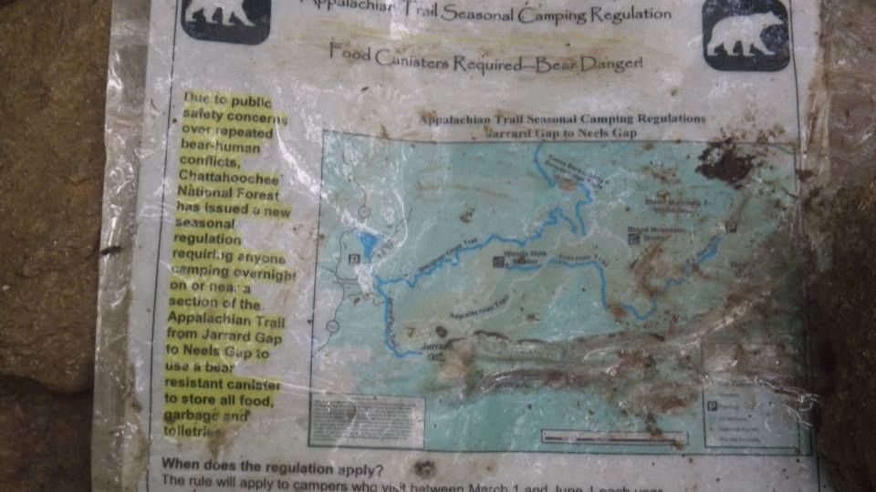
    Also, there is posted

    Basically saying you must Use a bear canister is camping between Neels Gap and Jarrard gap......But I think thats like a 5-10mile gap so all you need to do is hike past it and just not camp in the little section.
    Me: Ricky
    Husky: Jack
    Skeeter-Beeter Pro Hammock.
    From Dalton, Georgia (65 mi above Altanta, 15mi south of Chattanooga)

  7. #7
    Registered User
    Join Date
    01-16-2011
    Location
    On the trail
    Posts
    3,789
    Images
    3

    Default

    Personally I would make logistics easier and go from US 76 to Amicalola or vice versa. I would probably go SoBo and then spend a bit of time with your GF at the falls.

  8. #8
    Registered User
    Join Date
    09-06-2008
    Location
    Andrews, NC
    Age
    65
    Posts
    3,672

    Default

    I would end at AFSP. Food, showers, and lodging.

  9. #9
    Registered User
    Join Date
    07-21-2005
    Location
    Garner, NC
    Age
    58
    Posts
    649
    Images
    279

    Default

    Greetings. I also live in Raleigh. I hiked this section by combining 2 four night section hikes.

    The busy time for Georgia in in April when tons of through hikers hit the trail. Since so many hikers start in Georgia around the same time, the shelters tend
    to be large and there tends to be plenty of tent space near the shelters and at other places along the trail. Since you're hiking in August there will likely be
    plenty of space even if it is crowded for August. Still you should have a tent because there is always a chance a shelter will be full.

    I don't think you need that much water carrying capacity. You don't really need a GPS. You might want it if you love the gadgetry. I've never carried a
    trowel (all the shelters in GA have privies).

  10. #10
    Section Hiker
    Join Date
    01-26-2013
    Location
    California
    Age
    51
    Posts
    1,030

    Default

    Maybe it's a girl thing but I would like to have an extra shirt and shorts. Or at least underwear. You don't want to sleep in your wet stuff and if you're in/by a shelter you want something to put on. +1 for no trowel, if you have to poop in the woods the forest floor is soft enough to dig with a stick or your heel. The mutlitool may be overkill.

    Have you hiked on terrain that is steep, rocky and full of roots with those shoes before? If not, you should do that to get your feet used to them or see if you need something more. I wanted to love trail runners, but my feet are taking a beating.

    I hiked most of that section in June and going back in August to pick up where I left off. I enjoyed my hike tremendously!


    "Your comfort zone is a beautiful place, but nothing ever grows there.
    "


  11. #11
    Registered User
    Join Date
    06-21-2014
    Location
    North Carolina
    Age
    35
    Posts
    19

    Default

    Quote Originally Posted by slbirdnerd View Post
    Maybe it's a girl thing but I would like to have an extra shirt and shorts. Or at least underwear. You don't want to sleep in your wet stuff and if you're in/by a shelter you want something to put on. +1 for no trowel, if you have to poop in the woods the forest floor is soft enough to dig with a stick or your heel. The mutlitool may be overkill.

    Have you hiked on terrain that is steep, rocky and full of roots with those shoes before? If not, you should do that to get your feet used to them or see if you need something more. I wanted to love trail runners, but my feet are taking a beating.
    Thanks for the replies. Yea, an extra shirt and at least some underwear to sleep in would be nice. Ditching the trowel and mutlitool would help drop the weight I add for those. As far as the shoes, I love them. I've put close to 100 miles in them in different terrain with no problems. The only thing I was considering was trying some insoles for extra support/comfort. I've heard both positive and negative things about Superfeet so I'm a little hesitant there. I think I might buy some and test them out on a trail closer to home.

  12. #12
    Registered User
    Join Date
    07-21-2005
    Location
    Garner, NC
    Age
    58
    Posts
    649
    Images
    279

    Default

    Quote Originally Posted by jayw288 View Post
    Thanks for the replies. Yea, an extra shirt and at least some underwear to sleep in would be nice. Ditching the trowel and mutlitool would help drop the weight I add for those. As far as the shoes, I love them. I've put close to 100 miles in them in different terrain with no problems. The only thing I was considering was trying some insoles for extra support/comfort. I've heard both positive and negative things about Superfeet so I'm a little hesitant there. I think I might buy some and test them out on a trail closer to home.
    Oh, and I switched from boots to trail runners a few years ago. Although the southern half of Georgia is a bit worse than the northern half,
    overall it is not that rocky and doesn't have too many roots on the trail. Same with southern NC. I think you'll be fine with trail runners, but insoles
    might be a good addition.

    And personally, I never take an IPod hiking. I'd rather hear the woods. But that's obviously a personal choice.

    If you plan on sleeping in shelters, take earplugs. And read the instructions on putting them in (Reaching over your head, pull up on your ear with one
    hand while inserting the ear plug with the other. That way the ear plug goes farther in and stays in).

  13. #13
    Registered User Speakeasy TN's Avatar
    Join Date
    03-11-2010
    Location
    Chattanooga, Tenn
    Posts
    456

    Default

    I'd be interested in the water situation in this section. I don't think crowds would be an issue at all in this section unless you get a scout troop. Other than that, rock on with your plan. Best part of the section is PLENTY of bail outs if you hit something unexpected!

    And I'd second starting at AFSP. Tell the girlfriend it will be easier on her car than the FS road.

  14. #14
    Registered User
    Join Date
    06-02-2011
    Location
    Neptune Beach, Fl
    Age
    49
    Posts
    6,238

    Default

    Start AFSP and pick at winding stair gap just outside franklin(76).


    Sent from my iPhone using Tapatalk

  15. #15

    Default

    I hiked Dicks Creek to Fontana last June. There were a lot of hikers. I met 2 guys who were getting off after spending the night at Muskrat Creek shelter, it was full, plus tenters, they crammed in because they didn't bring a tent. I met them the next morning, no one was happy at that shelter. I also met a group of 4 adults and 2 kids, they were also getting off, it had been raining and we were at the older shelter that is right on the trail, can't remember its name, they only had a 2 person tent and were counting on shelters for the others to sleep in, that shelter is pretty small.
    You always need some sort of shelter.

  16. #16

    Default

    I to am interested in how your hike goes. My wife and I are planning our first section hike in August of 2015 and hiking NOBO and cover Georgia. We are planning hiking 85 miles in 7 days and leave the trail at Deep Gap in NC.

    Good luck and let us know about your experience.

    Root66

  17. #17
    Registered User AO2134's Avatar
    Join Date
    06-23-2014
    Location
    Gwinnett, Georgia
    Age
    38
    Posts
    635

    Default

    @ jayw288. I am planning on doing this same section over labor day weekend. August 29 to September 1. I am not sure if I can finish that section. That will be a pretty good pace. That is about 20 miles per day. I doubt I can do it. I've had a 30 mile day (without proper gear and 10 lb pack), but it destroyed me for a week after the day hike. Hopefully I can do 20 mile days. I don't know if you plan being there about this time but, if you are, maybe we will see each other on the trail. I would also take Turk6177's advice. That is my plan. Hike out to boarder and then hike back 3ish miles for easy access pickup. I think that is good advice.

    As for bears, I was there at the beginning of June. I did Amicalola to Long Creek Falls via AT approach and BMT and Long Creek Falls to Amicalola all on AT. It was a helish hike. I did not see a bear but, if I believed they actually existed (i don't. . . or I can't), I heard one on the approach trail. Also saw warning signs at Springer Shelter about increase bear activity. They actually discouraged camping there.

    If you got time, I'd start at Amicalola. Why not start at the beginning, or at least the southern terminus and go north? If you add Amicalola, it will add approximately 9 miles to your hike but you can add a cool falls which I think is the highest in GA. Also hit long creek falls 5.1ish miles into the AT.

    @ swisscross. It sounds like I will be there at the same time. Would you like to section hike together or compare notes/plans? It will be my first section hike.

  18. #18
    Registered User
    Join Date
    08-22-2010
    Location
    Fernandina Beach, Fl
    Age
    63
    Posts
    273

    Default

    Great section, although the approach trail from AFSP is a bit of a grind on day one. An alternaticve is to transport into Nimblewell Gap.This shortens the approach to something like 2.5 miles (vs 8). Water and shelters should not be a problem unless a group shows up. This happened to us at Blood Mountain. My son and I had the place to ourselves until about an hour before dark when about 20 scouts showed up and took over the place. Same thing happened this past summer in VA with a church group of 30+ kids. Suggest keeping the tent for this reason. Lots of tent sites if memory serves. Another option at the NC end is to hike into Standing Indian campground. It adds a few miles, but your girlfriends car will appreciate it. I am hiling Springer to Unicoi next week and will try to get a post on conditions.

  19. #19
    Registered User OnlyJohn's Avatar
    Join Date
    07-30-2010
    Location
    Cumming, GA
    Age
    57
    Posts
    65

    Default

    Just my $.02, but I like the hike from Winding Stair (Franklin) to Springer. It is about 110 mikes total. You have about ten days to cover it so that is a good daily mileage spread. If you go southbound your girlfriend can drop you right at the trail on Highway 64. She can pick you up at Springer at the other end or at Amicalola Falls if you want to hike eight more miles. Amicalola is a cool place to end if you have the extra time.
    if you want to go north bound you can start at Amicalola or Springer and get picked up at highway 64 on the north end. There is cell service at winding stair so you can call when you get to the highway.
    i live very near Amicalola Falls. If you need a ride / directions to Springer in order to bypass the approach trail, send me a p.m. And I will send you my phone number.

    OnlyJohn
    Dawsonville, GA

  20. #20
    Registered User
    Join Date
    06-26-2011
    Location
    Cumming, GA
    Age
    76
    Posts
    23

    Default

    The only time I've seen gobs of hikers was at the Hawk Mountain shelter about 8 miles north of Springer on March 2 and on Blood Mountain on the Fourth of July weekend. These last were day hikers who didn't even bring water, expecting water fountains at the top. On my other hikes, I've seen next to no one in the 55 miles I've done. I doubt if there will big crowds at shelters during the summer months.

Page 1 of 2 1 2 LastLast
++ New Posts ++

Tags for this Thread

Posting Permissions

  • You may not post new threads
  • You may not post replies
  • You may not post attachments
  • You may not edit your posts
  •