WhiteBlaze Pages 2024
A Complete Appalachian Trail Guidebook.
AVAILABLE NOW. $4 for interactive PDF(smartphone version)
Read more here WhiteBlaze Pages Store

Results 1 to 16 of 16
  1. #1

    Default NYC to trail and back

    Hello all,

    My friend and I are looking for a 3 day 2 night hike on the AT. We want to be able to take public transportation south from NYC close enough to a section of the trail if possible. We then want to hike back up towards NYC through the trail.

    I've done sections of it in the past, many loops. But we have mostly hiked the Adirondacks and many other places out west.

    any idea? thanks!

  2. #2
    Registered User
    Join Date
    06-18-2010
    Location
    NJ
    Age
    47
    Posts
    3,133
    Images
    1

    Default

    the trail technically doesnt run south from NYC... it runs north and sort of.... northwest? its a weird kind of bend in the trail.

    if youre willing to travel in any direction to the trail from NYC there are tons of options very nearyby

  3. #3

    Default

    Just noticed! thanks, im thinking ending it at Bear mtn. but not sure where to start

  4. #4
    Registered User
    Join Date
    01-07-2016
    Location
    Pace, Florida
    Age
    54
    Posts
    141

    Default

    Last August, I did a 2.5 day section hike using public transportation from Bear Mt Inn to Pawling. This is about 46 miles.

    I flew into Newark, took NJ Transit into NYC, walked to Grand Central, train to Peekskill, Uber to Bear Mt Inn ($17), hiking by 3pm. Overnight at Graymoor after 8 miles. Next day hike 19 miles to RPH Shelter. Next day hike 20 miles to Pawling by 4PM train (train only stops there on weekends), train to NYC, walk to Penn Station, train to NJ, stay in airport hotel, fly home next morning. (took advantage of free hotel shuttles)

    If you are coming directly from NYC that saves several steps. Hike was doable, but tiring. I was worried about being late for the train, but had 40 min to spare (I started hiking at 5:50 AM). Was surreal to be in Times Square on same day as being on the trail, especially for me who lives in rural Florida.

  5. #5
    -
    Join Date
    08-14-2005
    Location
    Fort Madison, IA
    Age
    60
    Posts
    1,672

    Default

    Quote Originally Posted by steve_zavocki View Post
    Last August, I did a 2.5 day section hike using public transportation from Bear Mt Inn to Pawling. This is about 46 miles.

    I flew into Newark, took NJ Transit into NYC, walked to Grand Central, train to Peekskill, Uber to Bear Mt Inn ($17), hiking by 3pm. Overnight at Graymoor after 8 miles. Next day hike 19 miles to RPH Shelter. Next day hike 20 miles to Pawling by 4PM train (train only stops there on weekends), train to NYC, walk to Penn Station, train to NJ, stay in airport hotel, fly home next morning. (took advantage of free hotel shuttles)

    If you are coming directly from NYC that saves several steps. Hike was doable, but tiring. I was worried about being late for the train, but had 40 min to spare (I started hiking at 5:50 AM). Was surreal to be in Times Square on same day as being on the trail, especially for me who lives in rural Florida.
    train only stops directly at AT sat, sun evening (to nyc) - pawling is regularity scheduled http://web.mta.info/mnr/html/plannin...018%202018.pdf

    IMO starting at bear mtn is a better option than the other way around, as the schedule / (purchase of tickets?) is more limited on that bus route

  6. #6
    Registered User
    Join Date
    01-28-2008
    Location
    Spokane, WA
    Age
    71
    Posts
    4,907

    Default

    If you are interested in a leisurely trip, Take the bus from the Port Authority terminal Arden Road on Rte 17, where the AT crosses the NY Thruway. Take an nice walk across Harriman State Park to Bear Mountain, Staying at Fingerboard and West Mountain Shelters. Catch the bus from Bear Mountain back to the city.

    If you are more ambitious, take the bus to either end, hike across on the AT, and return on any of several different routes.

    Easy logistics either way.
    "It's fun to have fun, but you have to know how." ---Dr. Seuss

  7. #7
    Registered User
    Join Date
    06-18-2010
    Location
    NJ
    Age
    47
    Posts
    3,133
    Images
    1

    Default

    if you arent set on it being all on the AT....

    take the A train to the GWB terminal, walk across the bridge, look for the aqua blazes. start following them. when you get to a big giant mess of a sign with arrows pointing in 12 different directions in harriman state park, follow the AT and the white blazes to the right until you get to the bear mountain inn. then take the bus home.

    theres several variants on the above idea possible. that one caveat i'll add is i have no idea how far youd need to walk on day 1 to reach legal camping and thatd be something to look into.

  8. #8
    I plan, therefore I am Strategic's Avatar
    Join Date
    08-18-2007
    Location
    Durham, NC
    Age
    62
    Posts
    380
    Images
    52

    Default

    Quote Originally Posted by BikeSwimRunRum View Post
    Just noticed! thanks, im thinking ending it at Bear mtn. but not sure where to start
    You should try the section from NY17a to Bear Mountain. It's a lot of fun and you can catch buses from the Port Authority that will take you directly to both ends of the section. The bus from Bear Mountain is pretty well known and you seem to have found that already. To get to the trailhead on NY17a, you can take the NJ Transit bus #197 that runs from the Port Authority to Warwick. There's a flag stop (i.e., tell the driver you want to get off there when you board) on NY17a at Kain Rd., just before the Greenwood Lake Park and Ride. Here the schedule. If you take the 7:30am run, it will get you to the trailhead by 9:30am, still plenty of time for a good day's hike.

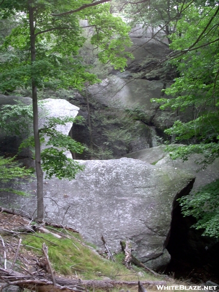
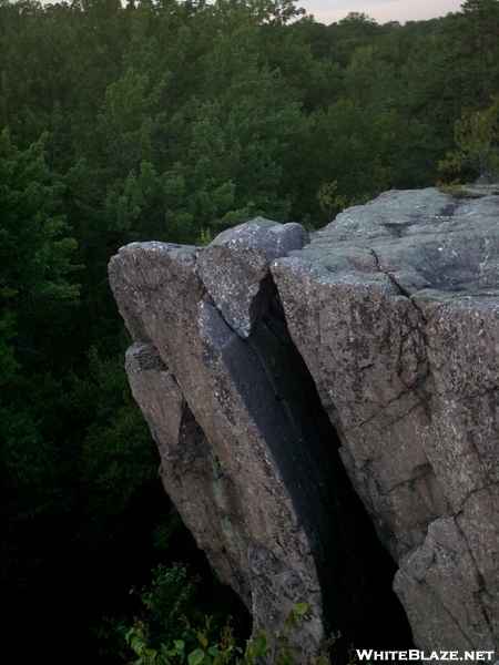
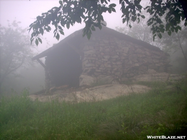
    The section is a lot of fun. You get on trail just south of Wildcat shelter. It's a good day from there to Fingerboard shelter for the first night, then another good day from there to West Mountain shelter for the second night and an easy last day with plenty of time to take the bus from Bear Mountain back to NYC. It has some great AT landmarks along the way, too. The Eastern Pinnacles, Cat Rocks, Fitzgerald Falls, the Agony Grind (which isn't agony at all if you're going NOBO), the Lemon Squeezer, the very cool old shelters of Harriman State Park (built in a style I've dubbed "Sleepy Hollow Rustic"), and Bear Mountain. You can even stop in at the Trailside Zoo at Bear Mountain at the end. Here are a few pics of things along the section:

    The Lemon Squeezer


    Cat Rocks


    West Mountain Shelter
    Strategy without tactics is the slowest route to victory. Tactics without strategy is the noise before defeat.
    Sun Tzu, The Art of War.

  9. #9

    Default

    Thank you so much everyone, these are all great ideas!
    BTW i normally use a hammock tent, is this ok?

    Quote Originally Posted by Strategic View Post
    You should try the section from NY17a to Bear Mountain. It's a lot of fun and you can catch buses from the Port Authority that will take you directly to both ends of the section. The bus from Bear Mountain is pretty well known and you seem to have found that already. To get to the trailhead on NY17a, you can take the NJ Transit bus #197 that runs from the Port Authority to Warwick. There's a flag stop (i.e., tell the driver you want to get off there when you board) on NY17a at Kain Rd., just before the Greenwood Lake Park and Ride. Here the schedule. If you take the 7:30am run, it will get you to the trailhead by 9:30am, still plenty of time for a good day's hike.

    The section is a lot of fun. You get on trail just south of Wildcat shelter. It's a good day from there to Fingerboard shelter for the first night, then another good day from there to West Mountain shelter for the second night and an easy last day with plenty of time to take the bus from Bear Mountain back to NYC. It has some great AT landmarks along the way, too. The Eastern Pinnacles, Cat Rocks, Fitzgerald Falls, the Agony Grind (which isn't agony at all if you're going NOBO), the Lemon Squeezer, the very cool old shelters of Harriman State Park (built in a style I've dubbed "Sleepy Hollow Rustic"), and Bear Mountain. You can even stop in at the Trailside Zoo at Bear Mountain at the end. Here are a few pics of things along the section:

    The Lemon Squeezer


    Cat Rocks


    West Mountain Shelter
    Roughly how many miles? Thank you!

  10. #10
    Registered User
    Join Date
    01-28-2008
    Location
    Spokane, WA
    Age
    71
    Posts
    4,907

    Default

    Quote Originally Posted by BikeSwimRunRum View Post
    Thank you so much everyone, these are all great ideas!
    BTW i normally use a hammock tent, is this ok?


    Roughly how many miles? Thank you!
    In Harriman, yes, if you camp near a shelter.
    "It's fun to have fun, but you have to know how." ---Dr. Seuss

  11. #11
    I plan, therefore I am Strategic's Avatar
    Join Date
    08-18-2007
    Location
    Durham, NC
    Age
    62
    Posts
    380
    Images
    52

    Default

    A hammock is fine on this section. I'm a hanger myself and had no problems finding good hang sites.

    The distances are pretty reasonable. Starting at NY17a, it's about 16 miles to Fingerboard shelter, another 9 miles from there to West Mountain shelter and about 7 miles from West Mountain to Bear Mountain Bridge. If you want to break that first day up some,you can stop short of Fingerboard shelter at the meadows beside Island Pond (there are some beautiful campsites there), which is about 13.5 miles from NY17a. That gives you a second day of about 11.5 miles to West Mountain shelter. I particularly like West Mountain since it's got a great view out over the Hudson valley. Be aware that Fingerboard and West Mountain don't have springs, so you have to pack water up from the stream valleys in this section. Those are the only reliable water sources in Harriman SP anyway (besides the taps at Lake Tiorati and Bear Mountain), but as long as you plan ahead it's not a problem.
    Strategy without tactics is the slowest route to victory. Tactics without strategy is the noise before defeat.
    Sun Tzu, The Art of War.

  12. #12

    Default

    Quote Originally Posted by Strategic View Post
    A hammock is fine on this section. I'm a hanger myself and had no problems finding good hang sites.

    The distances are pretty reasonable. Starting at NY17a, it's about 16 miles to Fingerboard shelter, another 9 miles from there to West Mountain shelter and about 7 miles from West Mountain to Bear Mountain Bridge. If you want to break that first day up some,you can stop short of Fingerboard shelter at the meadows beside Island Pond (there are some beautiful campsites there), which is about 13.5 miles from NY17a. That gives you a second day of about 11.5 miles to West Mountain shelter. I particularly like West Mountain since it's got a great view out over the Hudson valley. Be aware that Fingerboard and West Mountain don't have springs, so you have to pack water up from the stream valleys in this section. Those are the only reliable water sources in Harriman SP anyway (besides the taps at Lake Tiorati and Bear Mountain), but as long as you plan ahead it's not a problem.
    Thanks you! so Being that I am starting on Sunday and ending tues/wed. I should definitely start at NY17a and not Bear?

    Ill be taking my MSS as well

  13. #13
    I plan, therefore I am Strategic's Avatar
    Join Date
    08-18-2007
    Location
    Durham, NC
    Age
    62
    Posts
    380
    Images
    52

    Default

    Quote Originally Posted by BikeSwimRunRum View Post
    Thanks you! so Being that I am starting on Sunday and ending tues/wed. I should definitely start at NY17a and not Bear?

    Ill be taking my MSS as well
    I'd certainly avoid Bear Mountain on a Sunday. It will be full of weekend park-goers up from NYC (i.e., not hikers.) It can be a real crowd scene. On a weekday, it's much less crowded. The southern part of the section from NY17a to NY17 will be mostly empty this time of year, with maybe a few section hikers. You also descend the Agony Grind rather than climb up it, which is what you want. It's also a lot easier to get off the bus at Kain Rd. than it is to catch it there. You should be aware, though, that the last Short Line bus from Bear Mountain to NYC leaves at 3:19pm on weekdays (there's a 5:19pm on weekends.) That shouldn't really be a problem since it's only 7 miles from West Mountain.
    Strategy without tactics is the slowest route to victory. Tactics without strategy is the noise before defeat.
    Sun Tzu, The Art of War.

  14. #14
    Registered User
    Join Date
    09-08-2006
    Location
    Wilton CT
    Age
    77
    Posts
    1,097

    Default

    And if you miss the bus or it's inconvenient for you, you could walk over the Bear Mountain Bridge and go to Metro North's Manitou Station. It has limited service, so you would also need to keep an eye on its schedule.
    "It goes to show you never can tell." - Charles Edward Anderson Berry

  15. #15

    Default

    Quote Originally Posted by Strategic View Post
    I'd certainly avoid Bear Mountain on a Sunday. It will be full of weekend park-goers up from NYC (i.e., not hikers.) It can be a real crowd scene. On a weekday, it's much less crowded. The southern part of the section from NY17a to NY17 will be mostly empty this time of year, with maybe a few section hikers. You also descend the Agony Grind rather than climb up it, which is what you want. It's also a lot easier to get off the bus at Kain Rd. than it is to catch it there. You should be aware, though, that the last Short Line bus from Bear Mountain to NYC leaves at 3:19pm on weekdays (there's a 5:19pm on weekends.) That shouldn't really be a problem since it's only 7 miles from West Mountain.
    Thanks guys! So i'm actually going to take the earliest bus possible on Sunday morning and start hiking right away. I am trying to map it on ALLTRAILS but some where I lose the AT trail. Ill figure it out

  16. #16
    Clueless Weekender
    Join Date
    04-10-2011
    Location
    Niskayuna, New York
    Age
    68
    Posts
    3,879
    Journal Entries
    10

    Default

    Quote Originally Posted by tdoczi View Post
    if you arent set on it being all on the AT....

    take the A train to the GWB terminal, walk across the bridge, look for the aqua blazes. start following them. when you get to a big giant mess of a sign with arrows pointing in 12 different directions in harriman state park, follow the AT and the white blazes to the right until you get to the bear mountain inn. then take the bus home.

    theres several variants on the above idea possible. that one caveat i'll add is i have no idea how far youd need to walk on day 1 to reach legal camping and thatd be something to look into.
    That's the problem with the Long Path. It's a long way. Unless you get permission from a private property owner, the nearest legal camping is the Cheesecote town park (permit required). What most LP thru-hikers do is either (a) get permission from someone; Scout leaders have an advantage here since they can sometimes get permission at Alpine; (b) keep a low profile at rest stops on the parkway, (c) stay in a motel. There's a bus line that's parallel to the trail from Fort Lee to Haverstraw, so getting back to the motel isn't a huge problem - meaning that you can slackpack self-supported from NYC to Mount Ivy. The Super 8 and Best Western in Nyack are both right on the trail.

    Orange County is also a major problem for finding places to crash. That's why the AT bypass to High Point is allowed for a thru hike. Camping is no longer a big problem from Greenville north, although there are a couple of sections where you have to plan your stops carefully or you'll find yourself stranded on a too-long roadwalk.

    There's serious work being done on trying to improve the situation, but it involves dealing with suburbanites who don't know that there's any difference between 'hiker' and 'vagrant'.

    From Otisville north, camping is not a problem (a couple of stretches need to be planned, because it's alternating trail and roadwalk all through the Helderbergs), until you're in the Northern Excursion - not required for a thru-hike, but a lot of hikers do it anyway. On the Northern Excursion, you can make big miles on the roadwalk, and there are people (PM me if you need) who can help with slackpacking across the Mohawk Valley.

    I want to do the whole thing when I retire. (And I mean the whole thing, including the unblazed route from Northville to Lake Clear of Heart.) The concept of getting off the subway and immediately setting out on a thru-hike that ends up in (literally) trail-less wilderness is cool enough to be worth the annoyance of a few days hiking a suburban greenway.
    I always know where I am. I'm right here.

++ New Posts ++

Posting Permissions

  • You may not post new threads
  • You may not post replies
  • You may not post attachments
  • You may not edit your posts
  •