


Terrain: Ellicott's Rock & Chatooga River trails, GA/SC
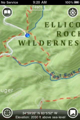
I've been waiting for AccuTerra's official release for a few months now, and they've been rolling out states' maps in waves. I purchased the basic app for $0.99, which gives you just a very basic map of the US that for hiking purposes isn't very helpful. From there, you can purchase detailed state maps (GA was $4.99) that allow you to zoom in closer. Even better are the National Parks/State Parks/Rec Areas that you can purchase for about $2.99, which give even closer maps and detail. The files are large (the base app is 10MB, and GA was 533MB), but the beauty of having them on the phone is no cell coverage as needed, as you can see in the screen caps..."NO SERVICE" GPS and compass obviously work anywhere. Plus you can certainly pick and choose which states/parks you want stored on the phone for your trip, leaving other large map files stored on your computer at home until you need them.
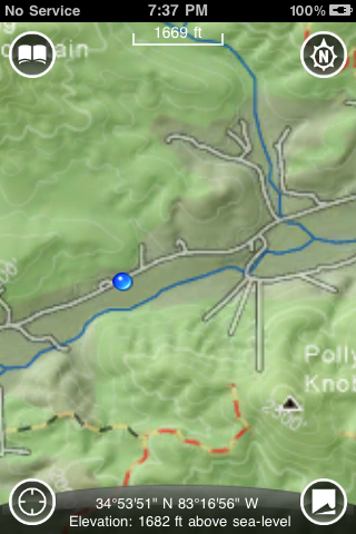
The app proved its usefulness Saturday morning. These trails are blazed very poorly in some areas, and other trails branch off and head elsewhere. Here we were about to head right from our position, but a quick review of the map showed that we needed to stay left in order to reach Ellicott's Rock. The trails weave in and out away from the water, and in some areas it's difficult to know which one will continue to follow it a mile down the trail.
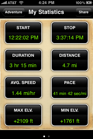
Here's the recap of the afternoon portion of our Saturday hike south. Various bits of data are all stored when you record a hike.
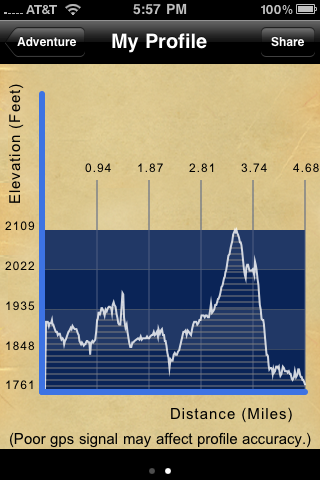
profile
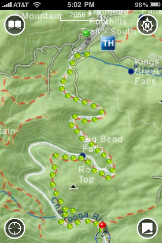
And finally here's the breadcrumb trail it captures when you record a hike. I have a concern about the scaling; at that zoom level the measurement segment says 2056', but if you were to snake that around the entire hike it doesn't seem to add up to 4.7 miles as shown in the recap screen.
In record mode, the app is certainly a battery hog, but used judiciously it is extremely helpful in unfamiliar areas. It corrected our mistakes several times and easily saved us an hour or more of u-turns and backtracking. The good news is you can hit the on/off switch on the top of the phone to turn the screen off but continue recording, which helps conserve the battery. The phone was at about 85% battery life at the start of the 4.7 miles, and had roughly 45% left about 4 hours later, with several instances of turning the screen on and checking our location in between. While recording a trek, you can use the iphone's camera to take pictures and they are stored at the precise points along the path when you go back to review it later. My only gripe here is you can only take pictures while recording a hike and using up valuable battery life. It would be nice if you could still take pictures in the app without having to record the hike and have it just tag your location to the photo. I'm hopeful that one day they'll expand and add more waypoint data stored on the maps, and will integrate the compass (it currently does not use it); augmented reality stuff would make this a hiker's best friend.
It has a few share functions where you can upload your hike details to Facebook as well as sending them via email from within the app. When you email the trip from within the AccuTerra app, this is an example of the link sent to your recipients:
http://maps.google.com/?t=p&q=http:/...1252860974.kml
The biggest negative is battery life if you're going to be recording or plan to be out several days. If you're not recording, you could stretch it by only turning the phone on and checking location sporadically. This is what I'm doing in two weeks when I take off for a week and will attempt to hike 70 miles of the Appalachian Trail. With a fully featured OS running it and free upgrades as they map more data, the possibilities for AccuTerra are extensive, particularly if they go down the augmented reality path, which I really hope they do (see the latest version of Yelp's app and the Monacle feature, and imagine that for waypoints!)
As for getting the phone dirty or wet, that's a concern if you're hiking in wet weather or fall knee-deep in a river like I did this morning. For me it's about weight savings. I will never hike without my phone in case of emergency (assuming I can get coverage, and on many parts of the AT down here I can), so buying a handheld GPS is just adding more weight to the pack. Most of the time though I expect to keep it in a ziplock in the top of my pack like I normally do, so the risk is minimal.
- Home
- Forum
- Journals
- Gallery
- What's New?
- Todays Posts
- 2,000 Miler Listing
-
Odd & Ends
- About WhiteBlaze/Tools
- About WhiteBlaze
- WhiteBlaze user agreement
- WhiteBlaze logo progression
- WhiteBlaze screen savers
- Purchase a banner spot
- Quick reference
- Usercp
- Subscribed Threads
- Members List
- Calendar
- Mark all forums read

 Reply With Quote


