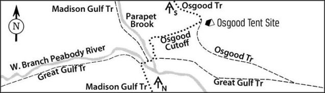
Oh, the signs weren't wrong, it was just the equivalent of having a sign in VT that says "long trail" but not "AT" and expecting the hiker to know that the long trail and the AT are the same in that section.Originally Posted by Slo-go'en

- Home
- Forum
- Journals
- Gallery
- What's New?
- Todays Posts
- 2,000 Miler Listing
-
Odd & Ends
- About WhiteBlaze/Tools
- About WhiteBlaze
- WhiteBlaze user agreement
- WhiteBlaze logo progression
- WhiteBlaze screen savers
- Purchase a banner spot
- Quick reference
- Usercp
- Subscribed Threads
- Members List
- Calendar
- Mark all forums read

 Reply With Quote