WhiteBlaze Pages 2024
A Complete Appalachian Trail Guidebook.
AVAILABLE NOW. $4 for interactive PDF(smartphone version)
Read more here WhiteBlaze Pages Store

Page 2 of 4 FirstFirst 1 2 3 4 LastLast
Results 21 to 40 of 67
  1. #21

    Default

    Here's an update on the trail bridge. The good news is that the old bridge is being dismantled.

    http://www.dcnr.state.pa.us/news/new...railbridge.htm

  2. #22

    Default

    Thanks for the update. It's another trail I'd like to thru after I retire. The section mentioned is really quite beautiful with all the mountain laurel, and relatively easy, too.
    As I live, declares the Lord God, I take no pleasure in the death of the wicked, but rather that the wicked turn back from his way and live. Ezekiel 33:11

  3. #23
    Registered User zr700's Avatar
    Join Date
    04-04-2006
    Location
    Berks, Pa
    Age
    51
    Posts
    17

    Default

    A single span 184 feet!!! 78" wide I-beams! "The abutments will constructed first then the beams will be set" THATS A GOOD PLAN!!!! LOL


    http://www.lhsc.net/page1.jpg

    http://www.lhsc.net/page2.jpg


    I'm a snowmobiler and a backpacker, I hope this gets in soon. We rode LH alot this winter they had over 18 foot of snow this winter. There is a culvert pipe under the TP just east of the old bridge. Another route might be Bakersville Rd bridge also east of foot bridge. Cross your fingers but dont hold your breath! I cant see a project this size going in for 1.5 mill Sounds way too cheap!

  4. #24
    Registered User zr700's Avatar
    Join Date
    04-04-2006
    Location
    Berks, Pa
    Age
    51
    Posts
    17

    Default

    Old Bridge is now history.

  5. #25
    AT virgin scottminot's Avatar
    Join Date
    03-10-2007
    Location
    Johnstown, Pennsylvania
    Age
    49
    Posts
    31

    Default

    Has the proposed detour been released yet?
    I've thru-hiked the trail three times and was planning my fourth trip later this year. I'm sure I can find my way around.

  6. #26
    Registered User Rotten Rob's Avatar
    Join Date
    04-26-2010
    Location
    Washington, PA
    Age
    38
    Posts
    9

    Default

    Here's a detour map. Gonna do the LHHT in July. CAN'T WAIT!!
    http://www.dcnr.state.pa.us/statepar...detour_pdf.pdf
    "Rocky Top, you'll always be home sweet home to me. Good ol' Rocky Top! Rocky Top Teenesee!"

  7. #27
    AT virgin scottminot's Avatar
    Join Date
    03-10-2007
    Location
    Johnstown, Pennsylvania
    Age
    49
    Posts
    31

    Default

    That's the route that I guessed they would use. I'm probably gonna do my fourth SOBO thru-hike around September.
    Enjoy your hike on the LHHT!

  8. #28
    Registered User crazyonelost's Avatar
    Join Date
    01-25-2009
    Location
    Wheeling,West Virginia
    Age
    57
    Posts
    80

    Default

    I planned for the NOBO of the LHT all winter and seen it was closed. but, I went ahead and planned the hike to the Rt 30 trail head. I didn't see a reroute until after the hike was planned. Once I can confirm a detour of the area,then maybe can plan the rest of the hike.

    Until then would start at the first trail head pass the turnpike and finish the rest of the trail. I would really hate missing the mileage between since I want to actually finish the whole trail.

    I still think they are crazy running a race on the trail. But am very impressed that they can do all 70 miles in a few hours. I guess I like taking my time too much

  9. #29

    Default Locals to LHHT

    Hi all... just found and joined the site. My girlfriend "mommabear" and I live very near the LHHT and spend several days a week running and hiking much of the LHHT. We live very near the 31 trail head. Recently we've met many "in need" folks. "in need" meaning dealing with the bridge outage, detours, etc. We've shuttled folks to various points North and South of the Turnpike. Its been a very positive experience meeting different hikers. We like to think of it as a good gesture towards others as we would appreciate having done for us. Its all good trail karma. So if you're "in-need" and would like some help with the detour, advice, whatever, we love and live on the local trails. Don't be shy, get in touch.

    If you're on the trail and some guy comes running by... give a friendly shout, its probablly me the woods ninja.

  10. #30

    Default

    Quote Originally Posted by woodsninja View Post
    Hi all... just found and joined the site. My girlfriend "mommabear" and I live very near the LHHT and spend several days a week running and hiking much of the LHHT. We live very near the 31 trail head. Recently we've met many "in need" folks. "in need" meaning dealing with the bridge outage, detours, etc. We've shuttled folks to various points North and South of the Turnpike. Its been a very positive experience meeting different hikers. We like to think of it as a good gesture towards others as we would appreciate having done for us. Its all good trail karma. So if you're "in-need" and would like some help with the detour, advice, whatever, we love and live on the local trails. Don't be shy, get in touch.

    If you're on the trail and some guy comes running by... give a friendly shout, its probablly me the woods ninja.
    Welcome to WB and nice to meet you. I hiked the LHT in March '08 and don't recall seeing any trail runners. Either too cold or too wet I guess.

    Thanks for helping out hikers.

  11. #31
    AT virgin scottminot's Avatar
    Join Date
    03-10-2007
    Location
    Johnstown, Pennsylvania
    Age
    49
    Posts
    31

    Default

    Quote Originally Posted by woodsninja View Post
    Hi all... just found and joined the site. My girlfriend "mommabear" and I live very near the LHHT and spend several days a week running and hiking much of the LHHT. We live very near the 31 trail head. Recently we've met many "in need" folks. "in need" meaning dealing with the bridge outage, detours, etc. We've shuttled folks to various points North and South of the Turnpike. Its been a very positive experience meeting different hikers. We like to think of it as a good gesture towards others as we would appreciate having done for us. Its all good trail karma. So if you're "in-need" and would like some help with the detour, advice, whatever, we love and live on the local trails. Don't be shy, get in touch.
    If you're on the trail and some guy comes running by... give a friendly shout, its probablly me the woods ninja.
    I'll be on the trail southbound for my 4th thru-hike this Sept. I live near the rt. 56 end of the trail and hike that area a lot.
    Maybe I'll see ya in Sept.

  12. #32

    Default

    Someone mentioned the drainage culvert.... Anyone have any more specific dinfo like how big it is, if it is blocked off, wildlife, etc? Seems to me that it would be perfect to get around the bridge being out. Hell, why don't they just build a tunnel underneath to begin with? There are more than enough mining outfits close by that could tunnel through that in no time.

  13. #33
    AT virgin scottminot's Avatar
    Join Date
    03-10-2007
    Location
    Johnstown, Pennsylvania
    Age
    49
    Posts
    31

    Default

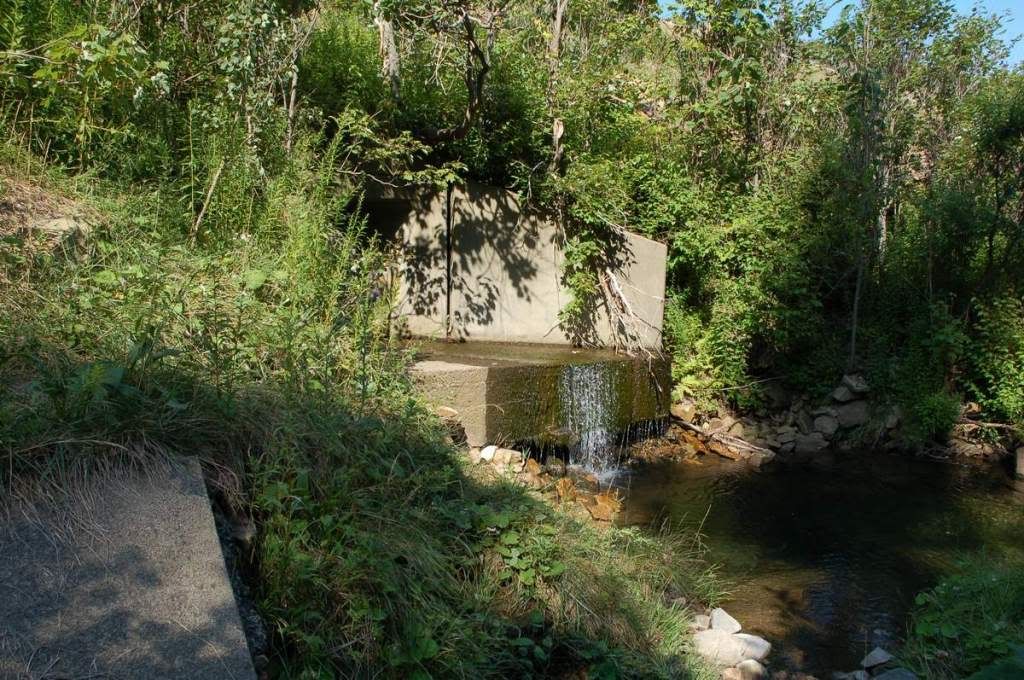
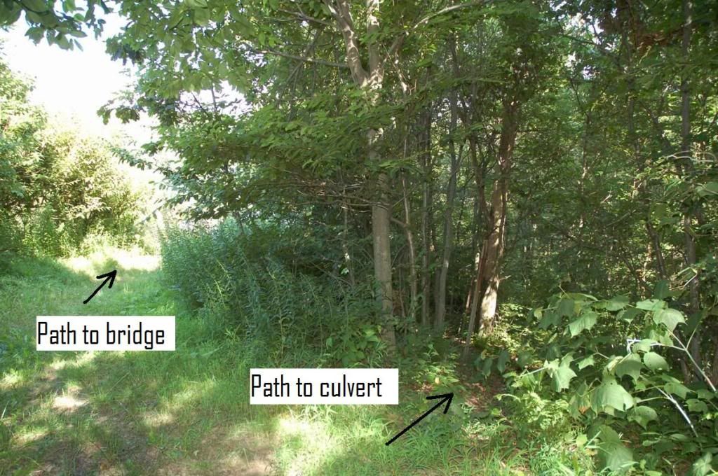
    There is a culvert east of the bridge location, been through it many times.
    Here are the directions if hiking nobo.


    Before the bridge there is a trail that cuts to the right. It's not marked and not well worn but is discernible. It runs parallel to a wire fence.


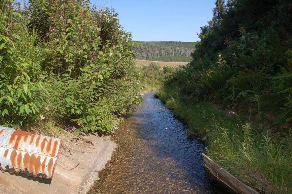
    Follow the trail east a little and it will lead you down to a small stream. Be careful the rocks are slippery. Follow the stream and it will turn to this


    You will soon find the culvert on your left. Be careful, it's a drop off.


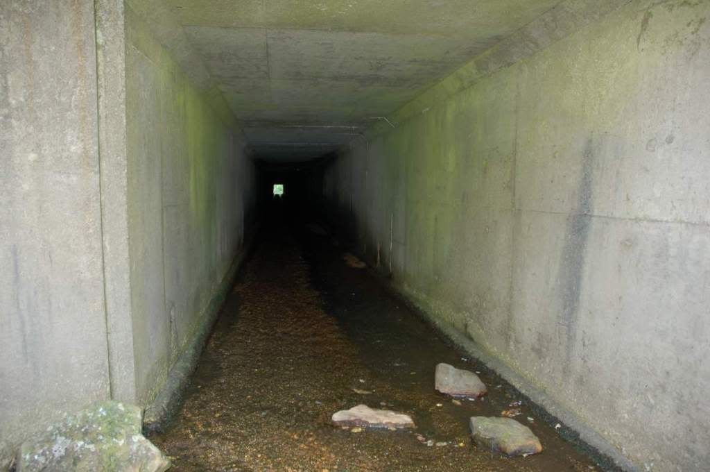
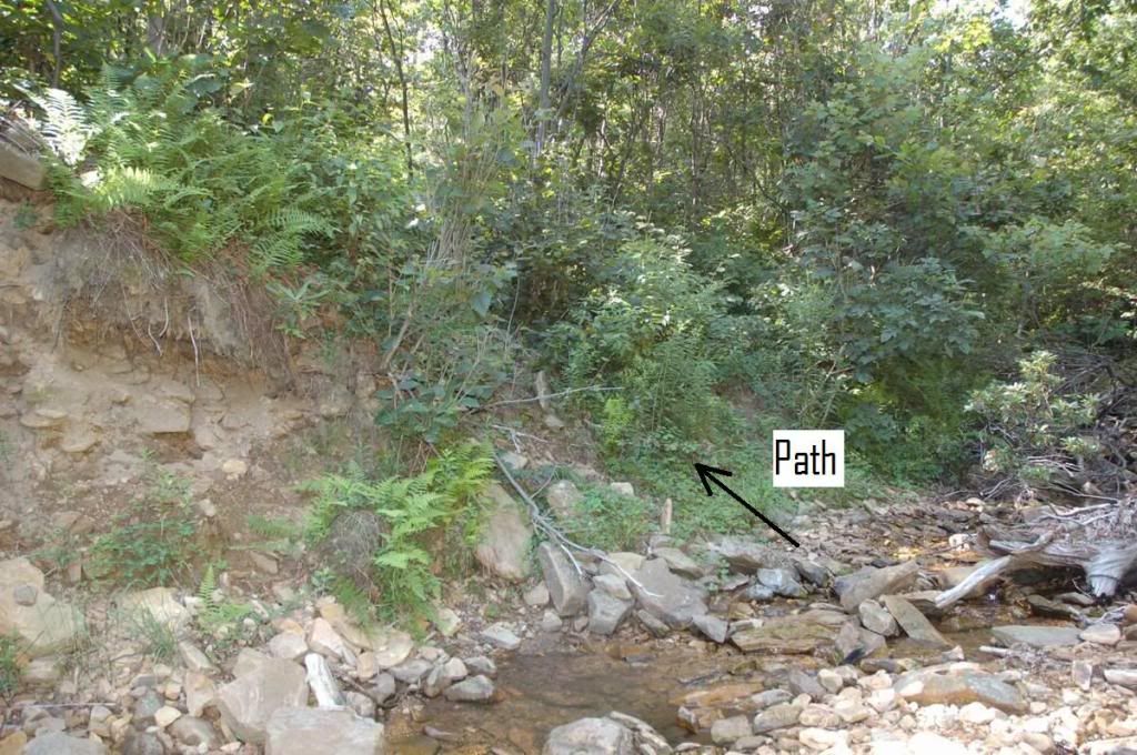
    Go through and walk up the stream for a hundred yards or so and find the path on the left.


    Follow the path that runs to the left of the stream until you see the log bridge and continue on your journey.
    One more note: You can go this route without getting wet if you're careful. I wasn't so lucky, I slipped on some rocks and fell in the water.


  14. #34
    Registered User
    Join Date
    07-19-2007
    Location
    Hummelstown & Tioga, PA
    Posts
    2,465

    Default

    How high is the inside of the culvert? Hard to get a sense of scale in the pics.

    PA's Mid State Trail crosses under US 322 at the Seven Mountains, officially, in a similar scenario - except that 20 years ago someone got a grant to pour a little bit of a sidewalk in the side of the channel bottom. I'm sure in the intervening two decades common sense has disappeared even further from the bureaucratic decision making process so likely the model can't be replicated.

    The resulting interior height of the MST crossing seems to be about 5'-6" and someone I was hiking with really scratched up the top of his silnylon pack on the rough concrete surface of the inside top of the culvert. I could see that happening here too unless that happens to be 8' or more inside.

  15. #35
    AT virgin scottminot's Avatar
    Join Date
    03-10-2007
    Location
    Johnstown, Pennsylvania
    Age
    49
    Posts
    31

    Default

    The culvert is about 6' x 6'.

  16. #36
    Registered User
    Join Date
    09-11-2002
    Location
    Manchester Ctr, VT
    Posts
    2,367
    Images
    13

    Default

    That is excellent information....not sure if PennDOT would approve but looks great to me.
    Order your copy of the Appalachian Trail Passport at www.ATPassport.com

    Green Mountain House Hostel
    Manchester Center, VT

    http://www.greenmountainhouse.net

  17. #37

    Default

    Looks like a no brainer to me. The Standing Stone Trail a little to the North uses the same sized culvert to cross under Rt 322.
    [COLOR="Blue"]Hokey Pokey [/COLOR]

  18. #38
    Registered User
    Join Date
    07-19-2007
    Location
    Hummelstown & Tioga, PA
    Posts
    2,465

    Default

    Quote Originally Posted by Hikerhead View Post
    Looks like a no brainer to me. The Standing Stone Trail a little to the North uses the same sized culvert to cross under Rt 322.
    Actually that was the Mid State. (And I KNOW you had a map... )

  19. #39

    Default

    Quote Originally Posted by ki0eh View Post
    Actually that was the Mid State. (And I KNOW you had a map... )
    You're right...my bad And thanks for the map and the shuttle. BTW, I did return the other map to your buddy when I found it in my mail box when I got home.
    [COLOR="Blue"]Hokey Pokey [/COLOR]

  20. #40

    Default

    Awesome. Thanks for the info. We'll be hiking nobo, any chance you have pics of the approach the other way? I know we could figure it out, buy one of my companions is OCD when it comes to "being prepared."

    On a related note, our hike has sadly been cut down to three days. I need some advice from some people who have done the whole trail. Is the northern or the southern part of the trail more "interesting?" I've hiked the southern portion between 7 Springs and Ohiopyle numerous times, but never any farther north. My companions have never been on the trail at all. If you had to choose, would you do the northern half or the southern half of the trail? Thanks for the replies.

Page 2 of 4 FirstFirst 1 2 3 4 LastLast
++ New Posts ++

Posting Permissions

  • You may not post new threads
  • You may not post replies
  • You may not post attachments
  • You may not edit your posts
  •